You are here: Home > Network List > TA - USArray Transportable Network (new EarthScope stations) Stations List
> Station J46A Howard City, MI, USA > Earthquake Result Viewer
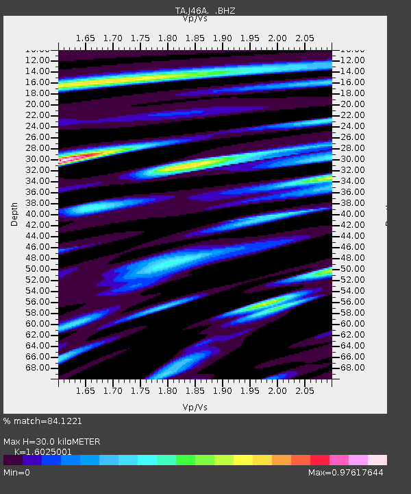
J46A Howard City, MI, USA - Earthquake Result Viewer
| Earthquake location: |
Central Chile |
| Earthquake latitude/longitude: |
-28.1/-70.7 |
| Earthquake time(UTC): |
2013/01/30 (030) 20:15:43 GMT |
| Earthquake Depth: |
45 km |
| Earthquake Magnitude: |
6.5 MB, 6.5 MS, 6.8 MW, 6.8 MW |
| Earthquake Catalog/Contributor: |
WHDF/NEIC |
|
| Network: |
TA USArray Transportable Network (new EarthScope stations) |
| Station: |
J46A Howard City, MI, USA |
| Lat/Lon: |
43.35 N/85.65 W |
| Elevation: |
275 m |
|
| Distance: |
72.4 deg |
| Az: |
348.581 deg |
| Baz: |
166.127 deg |
| Ray Param: |
0.053594675 |
| Estimated Moho Depth: |
30.0 km |
| Estimated Crust Vp/Vs: |
1.60 |
| Assumed Crust Vp: |
6.483 km/s |
| Estimated Crust Vs: |
4.045 km/s |
| Estimated Crust Poisson's Ratio: |
0.18 |
|
| Radial Match: |
84.1221 % |
| Radial Bump: |
400 |
| Transverse Match: |
75.41019 % |
| Transverse Bump: |
400 |
| SOD ConfigId: |
494114 |
| Insert Time: |
2013-04-27 04:16:22.869 +0000 |
| GWidth: |
2.5 |
| Max Bumps: |
400 |
| Tol: |
0.001 |
|

Signal To Noise
| Channel | StoN | STA | LTA |
| TA:J46A: :BHZ:20130130T20:26:33.949985Z | 14.811262 | 5.364133E-6 | 3.6216582E-7 |
| TA:J46A: :BHN:20130130T20:26:33.949985Z | 5.783248 | 2.216044E-6 | 3.831833E-7 |
| TA:J46A: :BHE:20130130T20:26:33.949985Z | 2.2402182 | 7.9622305E-7 | 3.5542212E-7 |
| Arrivals |
| Ps | 2.9 SECOND |
| PpPs | 12 SECOND |
| PsPs/PpSs | 14 SECOND |


