You are here: Home > Network List > TA - USArray Transportable Network (new EarthScope stations) Stations List
> Station H48A Harrisville, MI, USA > Earthquake Result Viewer
H48A Harrisville, MI, USA - Earthquake Result Viewer

| Earthquake location: |
Central Chile |
| Earthquake latitude/longitude: |
-28.1/-70.7 |
| Earthquake time(UTC): |
2013/01/30 (030) 20:15:43 GMT |
| Earthquake Depth: |
45 km |
| Earthquake Magnitude: |
6.5 MB, 6.5 MS, 6.8 MW, 6.8 MW |
| Earthquake Catalog/Contributor: |
WHDF/NEIC |
|
| Network: |
TA USArray Transportable Network (new EarthScope stations) |
| Station: |
H48A Harrisville, MI, USA |
| Lat/Lon: |
44.70 N/83.32 W |
| Elevation: |
244 m |
|
| Distance: |
73.4 deg |
| Az: |
350.603 deg |
| Baz: |
168.33 deg |
| Ray Param: |
0.05297295 |
| Estimated Moho Depth: |
37.0 km |
| Estimated Crust Vp/Vs: |
1.76 |
| Assumed Crust Vp: |
6.483 km/s |
| Estimated Crust Vs: |
3.683 km/s |
| Estimated Crust Poisson's Ratio: |
0.26 |
|
| Radial Match: |
89.09258 % |
| Radial Bump: |
400 |
| Transverse Match: |
72.60046 % |
| Transverse Bump: |
400 |
| SOD ConfigId: |
494114 |
| Insert Time: |
2013-04-27 04:17:57.938 +0000 |
| GWidth: |
2.5 |
| Max Bumps: |
400 |
| Tol: |
0.001 |
|
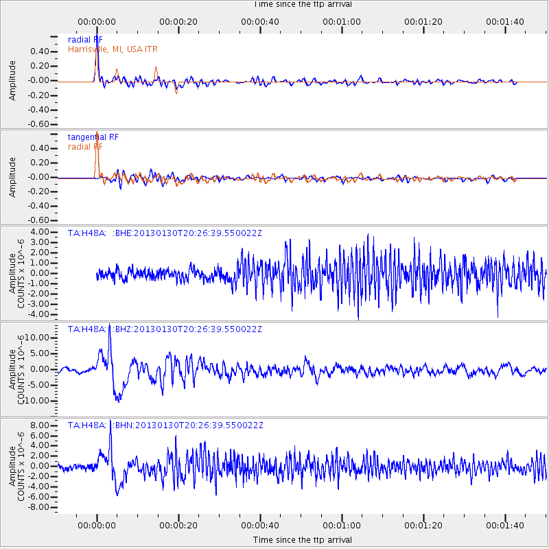
Signal To Noise
| Channel | StoN | STA | LTA |
| TA:H48A: :BHZ:20130130T20:26:39.550022Z | 12.035638 | 5.7612033E-6 | 4.786787E-7 |
| TA:H48A: :BHN:20130130T20:26:39.550022Z | 6.725561 | 2.9223806E-6 | 4.3451848E-7 |
| TA:H48A: :BHE:20130130T20:26:39.550022Z | 1.7028408 | 6.992609E-7 | 4.1064374E-7 |
| Arrivals |
| Ps | 4.5 SECOND |
| PpPs | 15 SECOND |
| PsPs/PpSs | 20 SECOND |


