You are here: Home > Network List > US - United States National Seismic Network Stations List
> Station MSO Missoula, Montana, USA > Earthquake Result Viewer
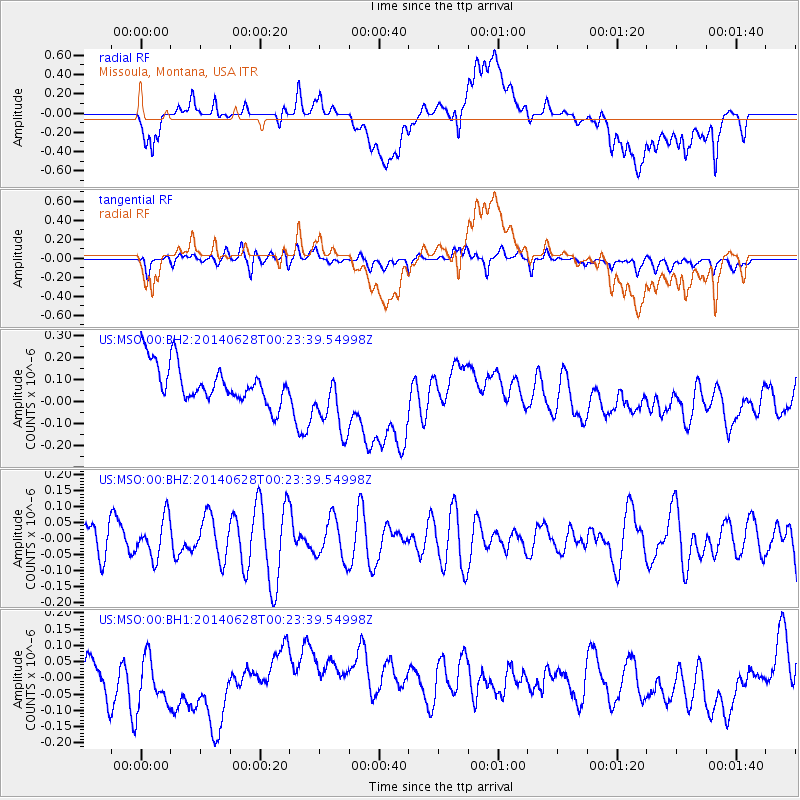
MSO Missoula, Montana, USA - Earthquake Result Viewer
*The percent match for this event was below the threshold and hence no stack was calculated.
| Earthquake location: |
Kermadec Islands, New Zealand |
| Earthquake latitude/longitude: |
-30.1/-177.2 |
| Earthquake time(UTC): |
2014/06/28 (179) 00:10:49 GMT |
| Earthquake Depth: |
32 km |
| Earthquake Magnitude: |
5.1 MW |
| Earthquake Catalog/Contributor: |
ISC/ISC |
|
| Network: |
US United States National Seismic Network |
| Station: |
MSO Missoula, Montana, USA |
| Lat/Lon: |
46.83 N/113.94 W |
| Elevation: |
1264 m |
|
| Distance: |
95.4 deg |
| Az: |
38.026 deg |
| Baz: |
231.048 deg |
| Ray Param: |
$rayparam |
*The percent match for this event was below the threshold and hence was not used in the summary stack. |
|
| Radial Match: |
28.915714 % |
| Radial Bump: |
400 |
| Transverse Match: |
38.60538 % |
| Transverse Bump: |
400 |
| SOD ConfigId: |
3390531 |
| Insert Time: |
2019-04-12 13:46:04.215 +0000 |
| GWidth: |
2.5 |
| Max Bumps: |
400 |
| Tol: |
0.001 |
|
Signal To Noise
| Channel | StoN | STA | LTA |
| US:MSO:00:BHZ:20140628T00:23:39.54998Z | 1.2290792 | 6.2014905E-8 | 5.0456396E-8 |
| US:MSO:00:BH1:20140628T00:23:39.54998Z | 1.6702181 | 1.0060368E-7 | 6.023386E-8 |
| US:MSO:00:BH2:20140628T00:23:39.54998Z | 1.8076681 | 1.590828E-7 | 8.8004434E-8 |
| Arrivals |
| Ps | |
| PpPs | |
| PsPs/PpSs | |


