You are here: Home > Network List > AU - Australian Seismological Centre Stations List
> Station KDU Kakadu, NT > Earthquake Result Viewer
KDU Kakadu, NT - Earthquake Result Viewer
| Earthquake location: |
Santa Cruz Islands |
| Earthquake latitude/longitude: |
-10.6/166.4 |
| Earthquake time(UTC): |
2013/01/31 (031) 03:33:43 GMT |
| Earthquake Depth: |
9.0 km |
| Earthquake Magnitude: |
6.1 MB, 6.1 MS, 6.1 MW, 6.0 MW |
| Earthquake Catalog/Contributor: |
WHDF/NEIC |
|
| Network: |
AU Australian Seismological Centre |
| Station: |
KDU Kakadu, NT |
| Lat/Lon: |
12.69 S/132.47 E |
| Elevation: |
46 m |
|
| Distance: |
33.2 deg |
| Az: |
263.094 deg |
| Baz: |
90.1 deg |
| Ray Param: |
0.07829917 |
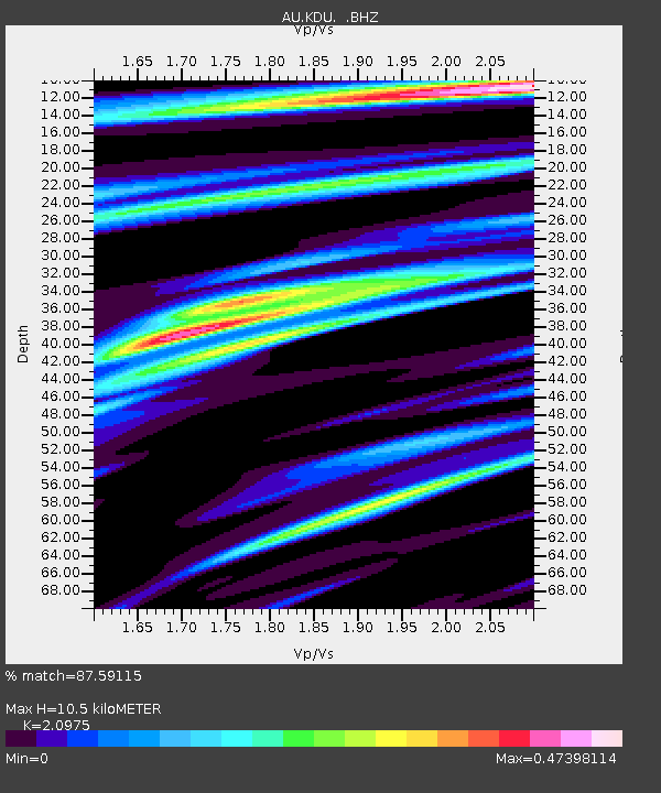
| Estimated Moho Depth: |
10.5 km |
| Estimated Crust Vp/Vs: |
2.10 |
| Assumed Crust Vp: |
6.61 km/s |
| Estimated Crust Vs: |
3.151 km/s |
| Estimated Crust Poisson's Ratio: |
0.35 |
|
| Radial Match: |
87.59115 % |
| Radial Bump: |
282 |
| Transverse Match: |
60.23424 % |
| Transverse Bump: |
400 |
| SOD ConfigId: |
494114 |
| Insert Time: |
2013-04-27 04:35:21.939 +0000 |
| GWidth: |
2.5 |
| Max Bumps: |
400 |
| Tol: |
0.001 |
|

Signal To Noise
| Channel | StoN | STA | LTA |
| AU:KDU: :BHZ:20130131T03:39:50.369994Z | 3.3902698 | 1.0242555E-6 | 3.0211623E-7 |
| AU:KDU: :BHN:20130131T03:39:50.369994Z | 1.5735646 | 2.3268144E-7 | 1.4786902E-7 |
| AU:KDU: :BHE:20130131T03:39:50.369994Z | 4.9057956 | 8.736211E-7 | 1.7807939E-7 |
| Arrivals |
| Ps | 1.9 SECOND |
| PpPs | 4.6 SECOND |
| PsPs/PpSs | 6.5 SECOND |


