You are here: Home > Network List > GT - Global Telemetered Seismograph Network (USAF/USGS) Stations List
> Station BDFB Brasilia, Brazil > Earthquake Result Viewer
BDFB Brasilia, Brazil - Earthquake Result Viewer
| Earthquake location: |
Guerrero, Mexico |
| Earthquake latitude/longitude: |
18.2/-101.4 |
| Earthquake time(UTC): |
1994/12/10 (344) 16:17:41 GMT |
| Earthquake Depth: |
67 km |
| Earthquake Magnitude: |
6.5 MB, 6.6 UNKNOWN, 6.5 MW |
| Earthquake Catalog/Contributor: |
WHDF/NEIC |
|
| Network: |
GT Global Telemetered Seismograph Network (USAF/USGS) |
| Station: |
BDFB Brasilia, Brazil |
| Lat/Lon: |
15.64 S/48.01 W |
| Elevation: |
1195 m |
|
| Distance: |
62.4 deg |
| Az: |
119.296 deg |
| Baz: |
300.653 deg |
| Ray Param: |
0.06008596 |
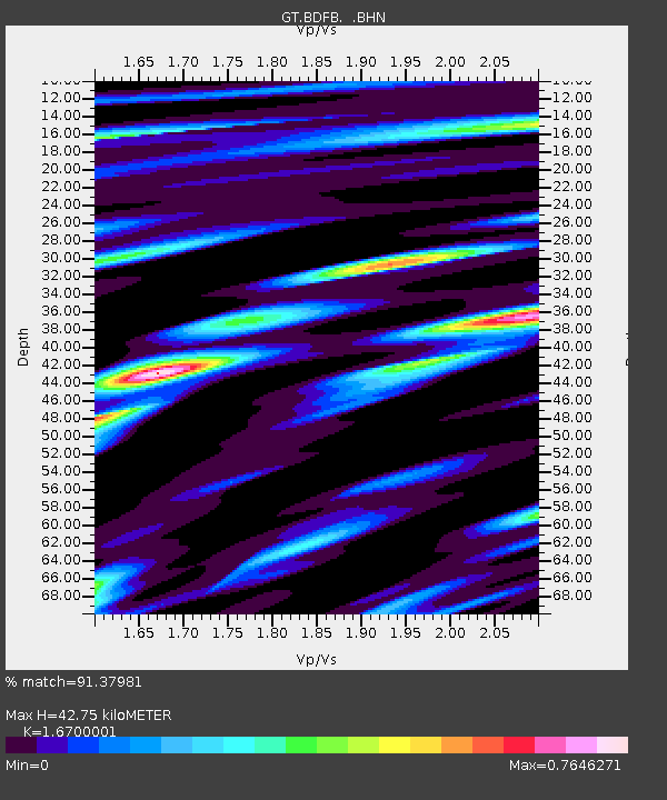
| Estimated Moho Depth: |
42.75 km |
| Estimated Crust Vp/Vs: |
1.67 |
| Assumed Crust Vp: |
6.419 km/s |
| Estimated Crust Vs: |
3.844 km/s |
| Estimated Crust Poisson's Ratio: |
0.22 |
|
| Radial Match: |
91.37981 % |
| Radial Bump: |
400 |
| Transverse Match: |
80.79596 % |
| Transverse Bump: |
400 |
| SOD ConfigId: |
16938 |
| Insert Time: |
2010-02-27 01:35:12.469 +0000 |
| GWidth: |
2.5 |
| Max Bumps: |
400 |
| Tol: |
0.001 |
|

Signal To Noise
| Channel | StoN | STA | LTA |
| GT:BDFB: :BHN:19941210T16:27:26.153015Z | 4.515364 | 5.4789916E-7 | 1.2134109E-7 |
| GT:BDFB: :BHE:19941210T16:27:26.153015Z | 13.978519 | 1.2075809E-6 | 8.638833E-8 |
| GT:BDFB: :BHZ:19941210T16:27:26.153015Z | 13.386207 | 2.2799375E-6 | 1.7031991E-7 |
| Arrivals |
| Ps | 4.7 SECOND |
| PpPs | 17 SECOND |
| PsPs/PpSs | 22 SECOND |


