You are here: Home > Network List > CI - Caltech Regional Seismic Network Stations List
> Station MPP McPhearson Peak > Earthquake Result Viewer
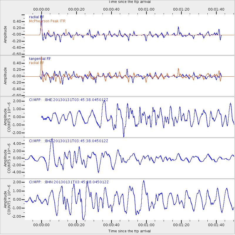
MPP McPhearson Peak - Earthquake Result Viewer
*The percent match for this event was below the threshold and hence no stack was calculated.
| Earthquake location: |
Santa Cruz Islands |
| Earthquake latitude/longitude: |
-10.6/166.4 |
| Earthquake time(UTC): |
2013/01/31 (031) 03:33:43 GMT |
| Earthquake Depth: |
9.0 km |
| Earthquake Magnitude: |
6.1 MB, 6.1 MS, 6.1 MW, 6.0 MW |
| Earthquake Catalog/Contributor: |
WHDF/NEIC |
|
| Network: |
CI Caltech Regional Seismic Network |
| Station: |
MPP McPhearson Peak |
| Lat/Lon: |
34.89 N/119.81 W |
| Elevation: |
1739 m |
|
| Distance: |
83.1 deg |
| Az: |
52.685 deg |
| Baz: |
251.999 deg |
| Ray Param: |
$rayparam |
*The percent match for this event was below the threshold and hence was not used in the summary stack. |
|
| Radial Match: |
73.82926 % |
| Radial Bump: |
400 |
| Transverse Match: |
81.6246 % |
| Transverse Bump: |
400 |
| SOD ConfigId: |
494114 |
| Insert Time: |
2013-04-27 04:40:53.970 +0000 |
| GWidth: |
2.5 |
| Max Bumps: |
400 |
| Tol: |
0.001 |
|
Signal To Noise
| Channel | StoN | STA | LTA |
| CI:MPP: :BHZ:20130131T03:45:38.045012Z | 3.9136808 | 1.4742977E-6 | 3.7670364E-7 |
| CI:MPP: :BHN:20130131T03:45:38.045012Z | 0.8204502 | 2.9460847E-7 | 3.590815E-7 |
| CI:MPP: :BHE:20130131T03:45:38.045012Z | 1.6539706 | 7.710733E-7 | 4.661953E-7 |
| Arrivals |
| Ps | |
| PpPs | |
| PsPs/PpSs | |


