You are here: Home > Network List > CI - Caltech Regional Seismic Network Stations List
> Station TUQ Turquiose Mountain, Baker, CA, USA > Earthquake Result Viewer
TUQ Turquiose Mountain, Baker, CA, USA - Earthquake Result Viewer
| Earthquake location: |
Santa Cruz Islands |
| Earthquake latitude/longitude: |
-10.6/166.4 |
| Earthquake time(UTC): |
2013/01/31 (031) 03:33:43 GMT |
| Earthquake Depth: |
9.0 km |
| Earthquake Magnitude: |
6.1 MB, 6.1 MS, 6.1 MW, 6.0 MW |
| Earthquake Catalog/Contributor: |
WHDF/NEIC |
|
| Network: |
CI Caltech Regional Seismic Network |
| Station: |
TUQ Turquiose Mountain, Baker, CA, USA |
| Lat/Lon: |
35.44 N/115.92 W |
| Elevation: |
1350 m |
|
| Distance: |
86.3 deg |
| Az: |
53.089 deg |
| Baz: |
254.267 deg |
| Ray Param: |
0.04417065 |
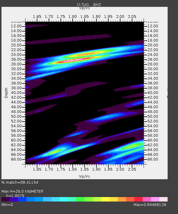
| Estimated Moho Depth: |
26.0 km |
| Estimated Crust Vp/Vs: |
1.81 |
| Assumed Crust Vp: |
6.276 km/s |
| Estimated Crust Vs: |
3.472 km/s |
| Estimated Crust Poisson's Ratio: |
0.28 |
|
| Radial Match: |
89.41154 % |
| Radial Bump: |
400 |
| Transverse Match: |
79.7021 % |
| Transverse Bump: |
400 |
| SOD ConfigId: |
494114 |
| Insert Time: |
2013-04-27 04:41:32.361 +0000 |
| GWidth: |
2.5 |
| Max Bumps: |
400 |
| Tol: |
0.001 |
|

Signal To Noise
| Channel | StoN | STA | LTA |
| CI:TUQ: :BHZ:20130131T03:45:54.194976Z | 10.089403 | 1.6017276E-6 | 1.5875347E-7 |
| CI:TUQ: :BHN:20130131T03:45:54.194976Z | 0.9239269 | 1.9532229E-7 | 2.1140448E-7 |
| CI:TUQ: :BHE:20130131T03:45:54.194976Z | 4.023817 | 5.8899843E-7 | 1.4637804E-7 |
| Arrivals |
| Ps | 3.4 SECOND |
| PpPs | 11 SECOND |
| PsPs/PpSs | 15 SECOND |


