NEE2 Needles Airport - Earthquake Result Viewer
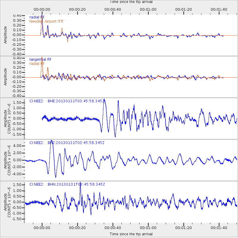
Earthquake location: Santa Cruz Islands
Earthquake latitude/longitude: -10.6/166.4
Earthquake time(UTC): 2013/01/31 (031) 03:33:43 GMT
Earthquake Depth: 9.0 km
Earthquake Magnitude: 6.1 MB, 6.1 MS, 6.1 MW, 6.0 MW
Earthquake Catalog/Contributor: WHDF/NEIC
Network: CI Caltech Regional Seismic Network
Station: NEE2 Needles Airport
Lat/Lon: 34.77 N/114.62 W
Elevation: 271 m
Distance: 87.1 deg
Az: 54.017 deg
Baz: 255.067 deg
Ray Param: 0.04354853
Estimated Moho Depth: 26.5 km
Estimated Crust Vp/Vs: 1.76
Assumed Crust Vp: 6.276 km/s
Estimated Crust Vs: 3.571 km/s
Estimated Crust Poisson's Ratio: 0.26
Radial Match: 93.193756 %
Radial Bump: 400
Transverse Match: 84.94821 %
Transverse Bump: 400
SOD ConfigId: 494114
Insert Time: 2013-04-27 04:42:07.282 +0000
GWidth: 2.5
Max Bumps: 400
Tol: 0.001

Signal To Noise

ChannelStoNSTALTA
CI:NEE2: :BHZ:20130131T03:45:58.345Z16.2371311.7656818E-61.0874346E-7
CI:NEE2: :BHN:20130131T03:45:58.345Z1.34154021.2677258E-79.449778E-8
CI:NEE2: :BHE:20130131T03:45:58.345Z4.91450175.417633E-71.10237686E-7
Arrivals
Ps3.3 SECOND
PpPs11 SECOND
PsPs/PpSs15 SECOND