You are here: Home > Network List > GT - Global Telemetered Seismograph Network (USAF/USGS) Stations List
> Station BDFB Brasilia, Brazil > Earthquake Result Viewer
BDFB Brasilia, Brazil - Earthquake Result Viewer
| Earthquake location: |
Northern Colombia |
| Earthquake latitude/longitude: |
7.1/-76.7 |
| Earthquake time(UTC): |
1994/09/13 (256) 10:01:34 GMT |
| Earthquake Depth: |
33 km |
| Earthquake Magnitude: |
5.8 MB, 5.6 MS |
| Earthquake Catalog/Contributor: |
WHDF/NEIC |
|
| Network: |
GT Global Telemetered Seismograph Network (USAF/USGS) |
| Station: |
BDFB Brasilia, Brazil |
| Lat/Lon: |
15.64 S/48.01 W |
| Elevation: |
1195 m |
|
| Distance: |
36.3 deg |
| Az: |
128.608 deg |
| Baz: |
306.391 deg |
| Ray Param: |
0.07669282 |
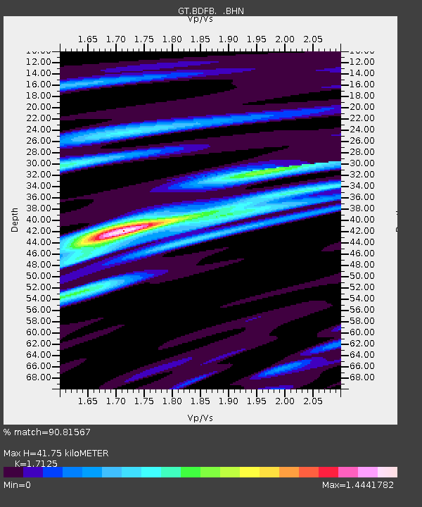
| Estimated Moho Depth: |
41.75 km |
| Estimated Crust Vp/Vs: |
1.71 |
| Assumed Crust Vp: |
6.419 km/s |
| Estimated Crust Vs: |
3.748 km/s |
| Estimated Crust Poisson's Ratio: |
0.24 |
|
| Radial Match: |
90.81567 % |
| Radial Bump: |
400 |
| Transverse Match: |
65.10734 % |
| Transverse Bump: |
400 |
| SOD ConfigId: |
17000 |
| Insert Time: |
2010-02-27 01:35:16.110 +0000 |
| GWidth: |
2.5 |
| Max Bumps: |
400 |
| Tol: |
0.001 |
|

Signal To Noise
| Channel | StoN | STA | LTA |
| GT:BDFB: :BHN:19940913T10:08:04.904004Z | 2.0961854 | 3.7072164E-7 | 1.7685537E-7 |
| GT:BDFB: :BHE:19940913T10:08:04.904004Z | 4.2269936 | 4.4969298E-7 | 1.06386004E-7 |
| GT:BDFB: :BHZ:19940913T10:08:04.904004Z | 4.5813456 | 8.3934594E-7 | 1.8320948E-7 |
| Arrivals |
| Ps | 5.0 SECOND |
| PpPs | 16 SECOND |
| PsPs/PpSs | 21 SECOND |


