You are here: Home > Network List > IC - New China Digital Seismograph Network Stations List
> Station ENH Enshi, Hubei Province, China > Earthquake Result Viewer
ENH Enshi, Hubei Province, China - Earthquake Result Viewer
| Earthquake location: |
Santa Cruz Islands |
| Earthquake latitude/longitude: |
-10.6/166.4 |
| Earthquake time(UTC): |
2013/01/31 (031) 03:33:43 GMT |
| Earthquake Depth: |
9.0 km |
| Earthquake Magnitude: |
6.1 MB, 6.1 MS, 6.1 MW, 6.0 MW |
| Earthquake Catalog/Contributor: |
WHDF/NEIC |
|
| Network: |
IC New China Digital Seismograph Network |
| Station: |
ENH Enshi, Hubei Province, China |
| Lat/Lon: |
30.28 N/109.49 E |
| Elevation: |
500 m |
|
| Distance: |
68.1 deg |
| Az: |
308.674 deg |
| Baz: |
117.48 deg |
| Ray Param: |
0.056516126 |
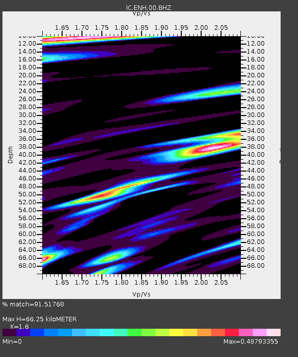
| Estimated Moho Depth: |
66.25 km |
| Estimated Crust Vp/Vs: |
1.60 |
| Assumed Crust Vp: |
6.083 km/s |
| Estimated Crust Vs: |
3.802 km/s |
| Estimated Crust Poisson's Ratio: |
0.18 |
|
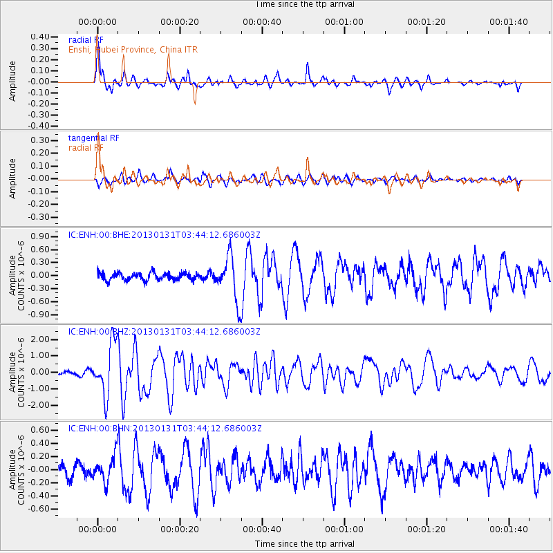
| Radial Match: |
91.51768 % |
| Radial Bump: |
400 |
| Transverse Match: |
78.56945 % |
| Transverse Bump: |
400 |
| SOD ConfigId: |
494114 |
| Insert Time: |
2013-04-27 04:43:02.187 +0000 |
| GWidth: |
2.5 |
| Max Bumps: |
400 |
| Tol: |
0.001 |
|
Signal To Noise
| Channel | StoN | STA | LTA |
| IC:ENH:00:BHZ:20130131T03:44:12.686003Z | 22.791405 | 1.681406E-6 | 7.377369E-8 |
| IC:ENH:00:BHN:20130131T03:44:12.686003Z | 2.5724344 | 2.16865E-7 | 8.4303416E-8 |
| IC:ENH:00:BHE:20130131T03:44:12.686003Z | 6.3020988 | 5.348848E-7 | 8.4874074E-8 |
| Arrivals |
| Ps | 6.8 SECOND |
| PpPs | 27 SECOND |
| PsPs/PpSs | 34 SECOND |


