You are here: Home > Network List > NE - New England Seismic Network Stations List
> Station EMMW Machias, ME, USA > Earthquake Result Viewer
EMMW Machias, ME, USA - Earthquake Result Viewer
*The percent match for this event was below the threshold and hence no stack was calculated.
| Earthquake location: |
Eastern Arizona |
| Earthquake latitude/longitude: |
32.6/-109.1 |
| Earthquake time(UTC): |
2014/06/29 (180) 04:59:34 GMT |
| Earthquake Depth: |
12 km |
| Earthquake Magnitude: |
5.3 MW |
| Earthquake Catalog/Contributor: |
ISC/ISC |
|
| Network: |
NE New England Seismic Network |
| Station: |
EMMW Machias, ME, USA |
| Lat/Lon: |
44.71 N/67.46 W |
| Elevation: |
35 m |
|
| Distance: |
34.3 deg |
| Az: |
57.126 deg |
| Baz: |
263.878 deg |
| Ray Param: |
$rayparam |
*The percent match for this event was below the threshold and hence was not used in the summary stack. |
|
| Radial Match: |
70.60969 % |
| Radial Bump: |
400 |
| Transverse Match: |
58.323757 % |
| Transverse Bump: |
360 |
| SOD ConfigId: |
3390531 |
| Insert Time: |
2019-04-12 13:50:25.250 +0000 |
| GWidth: |
2.5 |
| Max Bumps: |
400 |
| Tol: |
0.001 |
|
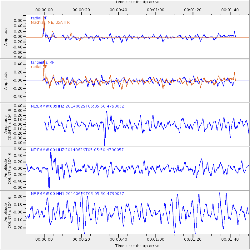
Signal To Noise
| Channel | StoN | STA | LTA |
| NE:EMMW:00:HHZ:20140629T05:05:50.479005Z | 1.96481 | 2.486962E-7 | 1.2657519E-7 |
| NE:EMMW:00:HH1:20140629T05:05:50.479005Z | 1.7712818 | 9.9538305E-8 | 5.6195635E-8 |
| NE:EMMW:00:HH2:20140629T05:05:50.479005Z | 2.1252508 | 1.6776067E-7 | 7.8936885E-8 |
| Arrivals |
| Ps | |
| PpPs | |
| PsPs/PpSs | |


