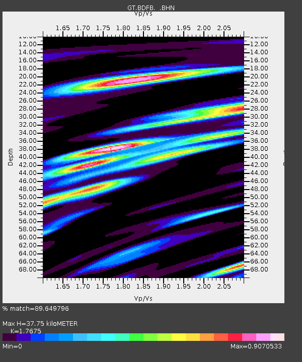
BDFB Brasilia, Brazil - Earthquake Result Viewer
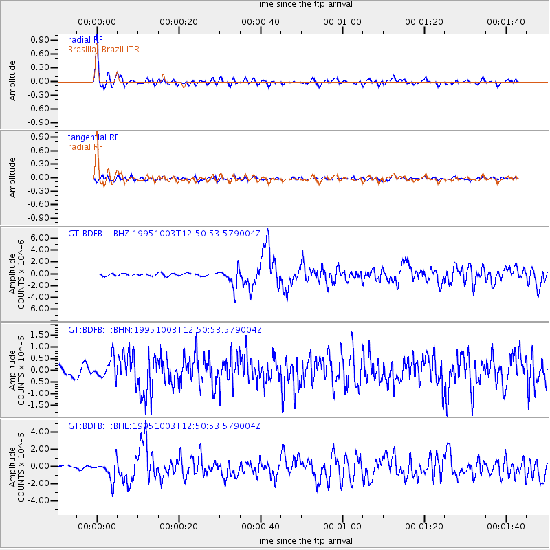
Earthquake location: Peru-Ecuador Border Region
Earthquake latitude/longitude: -2.8/-77.9
Earthquake time(UTC): 1995/10/03 (276) 12:45:00 GMT
Earthquake Depth: 33 km
Earthquake Magnitude: 6.0 MB, 6.1 MS, 5.9 UNKNOWN, 6.4 MW
Earthquake Catalog/Contributor: WHDF/NEIC
Network: GT Global Telemetered Seismograph Network (USAF/USGS)
Station: BDFB Brasilia, Brazil
Lat/Lon: 15.64 S/48.01 W
Elevation: 1195 m
Distance: 32.1 deg
Az: 115.297 deg
Baz: 290.397 deg
Ray Param: 0.07875981
Estimated Moho Depth: 37.75 km
Estimated Crust Vp/Vs: 1.77
Assumed Crust Vp: 6.419 km/s
Estimated Crust Vs: 3.632 km/s
Estimated Crust Poisson's Ratio: 0.26
Radial Match: 89.649796 %
Radial Bump: 400
Transverse Match: 69.049095 %
Transverse Bump: 400
SOD ConfigId: 6273
Insert Time: 2010-02-27 01:35:21.565 +0000
GWidth: 2.5
Max Bumps: 400
Tol: 0.001

Signal To Noise

ChannelStoNSTALTA
GT:BDFB: :BHN:19951003T12:50:53.579004Z2.1363724.197468E-71.9647645E-7
GT:BDFB: :BHE:19951003T12:50:53.579004Z5.1239221.1935424E-62.3293532E-7
GT:BDFB: :BHZ:19951003T12:50:53.579004Z8.2842051.639941E-61.9795998E-7
Arrivals
Ps4.9 SECOND
PpPs15 SECOND
PsPs/PpSs20 SECOND