You are here: Home > Network List > LB - Leo Brady Network Stations List
> Station DAC Darwin, Inyo County, California, USA > Earthquake Result Viewer
DAC Darwin, Inyo County, California, USA - Earthquake Result Viewer
| Earthquake location: |
Santa Cruz Islands |
| Earthquake latitude/longitude: |
-10.6/166.4 |
| Earthquake time(UTC): |
2013/01/31 (031) 03:33:43 GMT |
| Earthquake Depth: |
9.0 km |
| Earthquake Magnitude: |
6.1 MB, 6.1 MS, 6.1 MW, 6.0 MW |
| Earthquake Catalog/Contributor: |
WHDF/NEIC |
|
| Network: |
LB Leo Brady Network |
| Station: |
DAC Darwin, Inyo County, California, USA |
| Lat/Lon: |
36.28 N/117.59 W |
| Elevation: |
1813 m |
|
| Distance: |
85.2 deg |
| Az: |
51.9 deg |
| Baz: |
253.204 deg |
| Ray Param: |
0.044932734 |
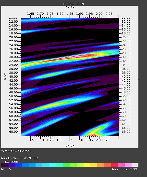
| Estimated Moho Depth: |
69.75 km |
| Estimated Crust Vp/Vs: |
1.97 |
| Assumed Crust Vp: |
6.279 km/s |
| Estimated Crust Vs: |
3.195 km/s |
| Estimated Crust Poisson's Ratio: |
0.33 |
|
| Radial Match: |
93.29569 % |
| Radial Bump: |
400 |
| Transverse Match: |
78.50534 % |
| Transverse Bump: |
400 |
| SOD ConfigId: |
494114 |
| Insert Time: |
2013-04-27 04:45:02.514 +0000 |
| GWidth: |
2.5 |
| Max Bumps: |
400 |
| Tol: |
0.001 |
|

Signal To Noise
| Channel | StoN | STA | LTA |
| LB:DAC: :BHZ:20130131T03:45:48.910979Z | 6.561183 | 1.2774489E-6 | 1.9469795E-7 |
| LB:DAC: :BHN:20130131T03:45:48.910979Z | 0.8050652 | 1.4325806E-7 | 1.7794592E-7 |
| LB:DAC: :BHE:20130131T03:45:48.910979Z | 2.0649633 | 3.4963506E-7 | 1.693178E-7 |
| Arrivals |
| Ps | 11 SECOND |
| PpPs | 32 SECOND |
| PsPs/PpSs | 43 SECOND |


