You are here: Home > Network List > TA - USArray Transportable Network (new EarthScope stations) Stations List
> Station A21K Barrow, AK, USA > Earthquake Result Viewer
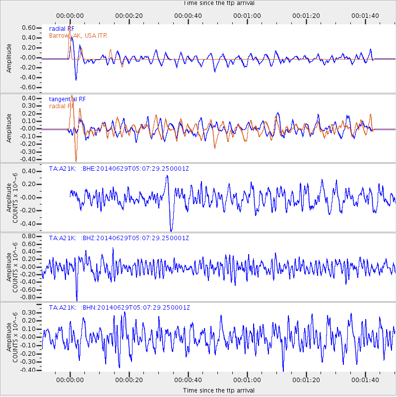
A21K Barrow, AK, USA - Earthquake Result Viewer
*The percent match for this event was below the threshold and hence no stack was calculated.
| Earthquake location: |
Eastern Arizona |
| Earthquake latitude/longitude: |
32.6/-109.1 |
| Earthquake time(UTC): |
2014/06/29 (180) 04:59:34 GMT |
| Earthquake Depth: |
12 km |
| Earthquake Magnitude: |
5.3 MW |
| Earthquake Catalog/Contributor: |
ISC/ISC |
|
| Network: |
TA USArray Transportable Network (new EarthScope stations) |
| Station: |
A21K Barrow, AK, USA |
| Lat/Lon: |
71.32 N/156.62 W |
| Elevation: |
577 m |
|
| Distance: |
46.3 deg |
| Az: |
340.802 deg |
| Baz: |
120.503 deg |
| Ray Param: |
$rayparam |
*The percent match for this event was below the threshold and hence was not used in the summary stack. |
|
| Radial Match: |
60.44285 % |
| Radial Bump: |
400 |
| Transverse Match: |
62.20014 % |
| Transverse Bump: |
400 |
| SOD ConfigId: |
3390531 |
| Insert Time: |
2019-04-12 13:51:06.110 +0000 |
| GWidth: |
2.5 |
| Max Bumps: |
400 |
| Tol: |
0.001 |
|
Signal To Noise
| Channel | StoN | STA | LTA |
| TA:A21K: :BHZ:20140629T05:07:29.250001Z | 1.9692233 | 2.7133163E-7 | 1.3778612E-7 |
| TA:A21K: :BHN:20140629T05:07:29.250001Z | 1.5916024 | 1.3568E-7 | 8.524742E-8 |
| TA:A21K: :BHE:20140629T05:07:29.250001Z | 2.9380367 | 2.3752955E-7 | 8.084635E-8 |
| Arrivals |
| Ps | |
| PpPs | |
| PsPs/PpSs | |


