You are here: Home > Network List > TA - USArray Transportable Network (new EarthScope stations) Stations List
> Station D58A Chemin du LacGrosbois, Trois-Rives, QC, CAN > Earthquake Result Viewer
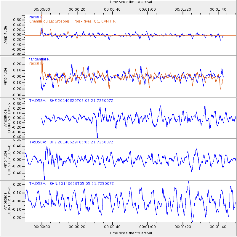
D58A Chemin du LacGrosbois, Trois-Rives, QC, CAN - Earthquake Result Viewer
*The percent match for this event was below the threshold and hence no stack was calculated.
| Earthquake location: |
Eastern Arizona |
| Earthquake latitude/longitude: |
32.6/-109.1 |
| Earthquake time(UTC): |
2014/06/29 (180) 04:59:34 GMT |
| Earthquake Depth: |
12 km |
| Earthquake Magnitude: |
5.3 MW |
| Earthquake Catalog/Contributor: |
ISC/ISC |
|
| Network: |
TA USArray Transportable Network (new EarthScope stations) |
| Station: |
D58A Chemin du LacGrosbois, Trois-Rives, QC, CAN |
| Lat/Lon: |
47.10 N/72.88 W |
| Elevation: |
398 m |
|
| Distance: |
31.0 deg |
| Az: |
51.51 deg |
| Baz: |
255.262 deg |
| Ray Param: |
$rayparam |
*The percent match for this event was below the threshold and hence was not used in the summary stack. |
|
| Radial Match: |
49.04856 % |
| Radial Bump: |
400 |
| Transverse Match: |
64.82601 % |
| Transverse Bump: |
400 |
| SOD ConfigId: |
3390531 |
| Insert Time: |
2019-04-12 13:51:06.667 +0000 |
| GWidth: |
2.5 |
| Max Bumps: |
400 |
| Tol: |
0.001 |
|
Signal To Noise
| Channel | StoN | STA | LTA |
| TA:D58A: :BHZ:20140629T05:05:21.725007Z | 2.6822093 | 2.5298252E-7 | 9.431871E-8 |
| TA:D58A: :BHN:20140629T05:05:21.725007Z | 0.9334382 | 5.4941733E-8 | 5.8859527E-8 |
| TA:D58A: :BHE:20140629T05:05:21.725007Z | 3.551203 | 1.5691256E-7 | 4.418575E-8 |
| Arrivals |
| Ps | |
| PpPs | |
| PsPs/PpSs | |


