You are here: Home > Network List > TA - USArray Transportable Network (new EarthScope stations) Stations List
> Station D03D Eldon, WA, USA > Earthquake Result Viewer
D03D Eldon, WA, USA - Earthquake Result Viewer
| Earthquake location: |
Santa Cruz Islands |
| Earthquake latitude/longitude: |
-10.6/166.4 |
| Earthquake time(UTC): |
2013/01/31 (031) 03:33:43 GMT |
| Earthquake Depth: |
9.0 km |
| Earthquake Magnitude: |
6.1 MB, 6.1 MS, 6.1 MW, 6.0 MW |
| Earthquake Catalog/Contributor: |
WHDF/NEIC |
|
| Network: |
TA USArray Transportable Network (new EarthScope stations) |
| Station: |
D03D Eldon, WA, USA |
| Lat/Lon: |
47.53 N/123.09 W |
| Elevation: |
262 m |
|
| Distance: |
85.0 deg |
| Az: |
39.892 deg |
| Baz: |
248.5 deg |
| Ray Param: |
0.04507302 |
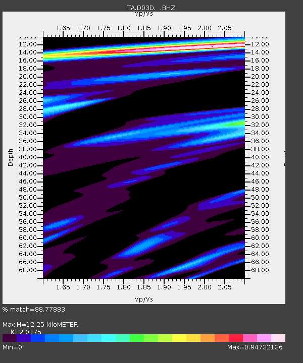
| Estimated Moho Depth: |
12.25 km |
| Estimated Crust Vp/Vs: |
2.02 |
| Assumed Crust Vp: |
6.566 km/s |
| Estimated Crust Vs: |
3.255 km/s |
| Estimated Crust Poisson's Ratio: |
0.34 |
|
| Radial Match: |
88.77883 % |
| Radial Bump: |
400 |
| Transverse Match: |
94.182335 % |
| Transverse Bump: |
384 |
| SOD ConfigId: |
494114 |
| Insert Time: |
2013-04-27 04:48:24.783 +0000 |
| GWidth: |
2.5 |
| Max Bumps: |
400 |
| Tol: |
0.001 |
|

Signal To Noise
| Channel | StoN | STA | LTA |
| TA:D03D: :BHZ:20130131T03:45:47.94998Z | 4.3291807 | 1.3540779E-6 | 3.1277926E-7 |
| TA:D03D: :BHN:20130131T03:45:47.94998Z | 1.190283 | 3.4405932E-7 | 2.8905674E-7 |
| TA:D03D: :BHE:20130131T03:45:47.94998Z | 2.1204174 | 4.0187211E-7 | 1.8952501E-7 |
| Arrivals |
| Ps | 1.9 SECOND |
| PpPs | 5.5 SECOND |
| PsPs/PpSs | 7.4 SECOND |


