You are here: Home > Network List > TA - USArray Transportable Network (new EarthScope stations) Stations List
> Station J61A Chester, VT, USA > Earthquake Result Viewer
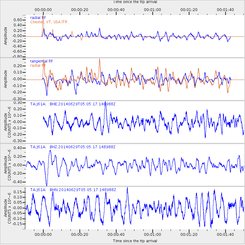
J61A Chester, VT, USA - Earthquake Result Viewer
*The percent match for this event was below the threshold and hence no stack was calculated.
| Earthquake location: |
Eastern Arizona |
| Earthquake latitude/longitude: |
32.6/-109.1 |
| Earthquake time(UTC): |
2014/06/29 (180) 04:59:34 GMT |
| Earthquake Depth: |
12 km |
| Earthquake Magnitude: |
5.3 MW |
| Earthquake Catalog/Contributor: |
ISC/ISC |
|
| Network: |
TA USArray Transportable Network (new EarthScope stations) |
| Station: |
J61A Chester, VT, USA |
| Lat/Lon: |
43.35 N/72.55 W |
| Elevation: |
253 m |
|
| Distance: |
30.5 deg |
| Az: |
58.785 deg |
| Baz: |
261.747 deg |
| Ray Param: |
$rayparam |
*The percent match for this event was below the threshold and hence was not used in the summary stack. |
|
| Radial Match: |
65.32456 % |
| Radial Bump: |
400 |
| Transverse Match: |
59.056828 % |
| Transverse Bump: |
400 |
| SOD ConfigId: |
3390531 |
| Insert Time: |
2019-04-12 13:51:31.095 +0000 |
| GWidth: |
2.5 |
| Max Bumps: |
400 |
| Tol: |
0.001 |
|
Signal To Noise
| Channel | StoN | STA | LTA |
| TA:J61A: :BHZ:20140629T05:05:17.148988Z | 4.743409 | 2.488638E-7 | 5.246518E-8 |
| TA:J61A: :BHN:20140629T05:05:17.148988Z | 2.1404436 | 8.812907E-8 | 4.1173273E-8 |
| TA:J61A: :BHE:20140629T05:05:17.148988Z | 2.0794804 | 1.4288165E-7 | 6.8710264E-8 |
| Arrivals |
| Ps | |
| PpPs | |
| PsPs/PpSs | |


