You are here: Home > Network List > CI - Caltech Regional Seismic Network Stations List
> Station LGU LGU, Camarillo, CA, USA > Earthquake Result Viewer
LGU LGU, Camarillo, CA, USA - Earthquake Result Viewer
*The percent match for this event was below the threshold and hence no stack was calculated.
| Earthquake location: |
Santa Cruz Islands |
| Earthquake latitude/longitude: |
-10.7/166.4 |
| Earthquake time(UTC): |
2013/01/31 (031) 03:57:56 GMT |
| Earthquake Depth: |
10 km |
| Earthquake Magnitude: |
5.6 MB, 5.9 MS, 5.8 MW |
| Earthquake Catalog/Contributor: |
WHDF/NEIC |
|
| Network: |
CI Caltech Regional Seismic Network |
| Station: |
LGU LGU, Camarillo, CA, USA |
| Lat/Lon: |
34.11 N/119.07 W |
| Elevation: |
416 m |
|
| Distance: |
83.4 deg |
| Az: |
53.614 deg |
| Baz: |
252.488 deg |
| Ray Param: |
$rayparam |
*The percent match for this event was below the threshold and hence was not used in the summary stack. |
|
| Radial Match: |
80.6787 % |
| Radial Bump: |
363 |
| Transverse Match: |
56.590523 % |
| Transverse Bump: |
400 |
| SOD ConfigId: |
494114 |
| Insert Time: |
2013-04-27 04:58:32.233 +0000 |
| GWidth: |
2.5 |
| Max Bumps: |
400 |
| Tol: |
0.001 |
|
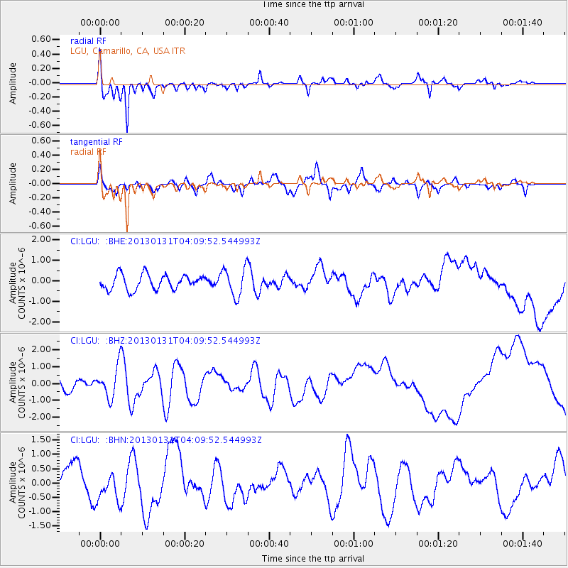
Signal To Noise
| Channel | StoN | STA | LTA |
| CI:LGU: :BHZ:20130131T04:09:52.544993Z | 3.5302546 | 9.4932875E-7 | 2.689123E-7 |
| CI:LGU: :BHN:20130131T04:09:52.544993Z | 1.1710571 | 5.317393E-7 | 4.5406776E-7 |
| CI:LGU: :BHE:20130131T04:09:52.544993Z | 1.9897449 | 7.2115625E-7 | 3.624365E-7 |
| Arrivals |
| Ps | |
| PpPs | |
| PsPs/PpSs | |


