You are here: Home > Network List > CI - Caltech Regional Seismic Network Stations List
> Station BFS Mt Baldy Forest Station > Earthquake Result Viewer
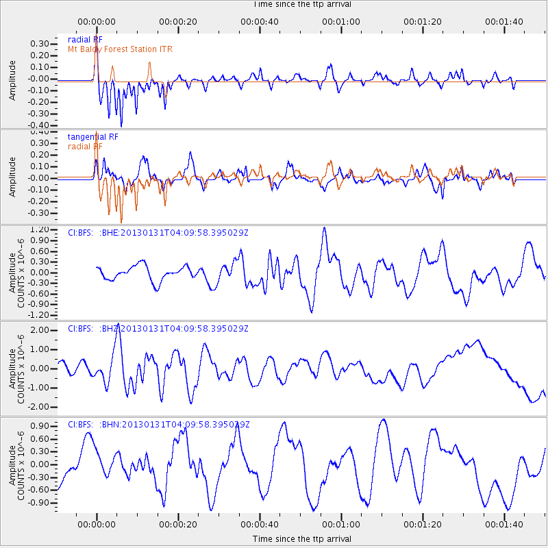
BFS Mt Baldy Forest Station - Earthquake Result Viewer

| Earthquake location: |
Santa Cruz Islands |
| Earthquake latitude/longitude: |
-10.7/166.4 |
| Earthquake time(UTC): |
2013/01/31 (031) 03:57:56 GMT |
| Earthquake Depth: |
10 km |
| Earthquake Magnitude: |
5.6 MB, 5.9 MS, 5.8 MW |
| Earthquake Catalog/Contributor: |
WHDF/NEIC |
|
| Network: |
CI Caltech Regional Seismic Network |
| Station: |
BFS Mt Baldy Forest Station |
| Lat/Lon: |
34.24 N/117.66 W |
| Elevation: |
1312 m |
|
| Distance: |
84.6 deg |
| Az: |
53.834 deg |
| Baz: |
253.298 deg |
| Ray Param: |
0.045378655 |
| Estimated Moho Depth: |
20.0 km |
| Estimated Crust Vp/Vs: |
1.61 |
| Assumed Crust Vp: |
6.276 km/s |
| Estimated Crust Vs: |
3.898 km/s |
| Estimated Crust Poisson's Ratio: |
0.19 |
|
| Radial Match: |
89.92897 % |
| Radial Bump: |
327 |
| Transverse Match: |
50.74151 % |
| Transverse Bump: |
346 |
| SOD ConfigId: |
494114 |
| Insert Time: |
2013-04-27 04:59:13.647 +0000 |
| GWidth: |
2.5 |
| Max Bumps: |
400 |
| Tol: |
0.001 |
|
Signal To Noise
| Channel | StoN | STA | LTA |
| CI:BFS: :BHZ:20130131T04:09:58.395029Z | 2.938756 | 7.307475E-7 | 2.4865878E-7 |
| CI:BFS: :BHN:20130131T04:09:58.395029Z | 1.124705 | 3.0841926E-7 | 2.7422237E-7 |
| CI:BFS: :BHE:20130131T04:09:58.395029Z | 1.3629367 | 2.6948192E-7 | 1.9772152E-7 |
| Arrivals |
| Ps | 2.0 SECOND |
| PpPs | 8.1 SECOND |
| PsPs/PpSs | 10 SECOND |


