You are here: Home > Network List > TA - USArray Transportable Network (new EarthScope stations) Stations List
> Station J04D Umpqua National Forest, Toketee, OR, USA > Earthquake Result Viewer
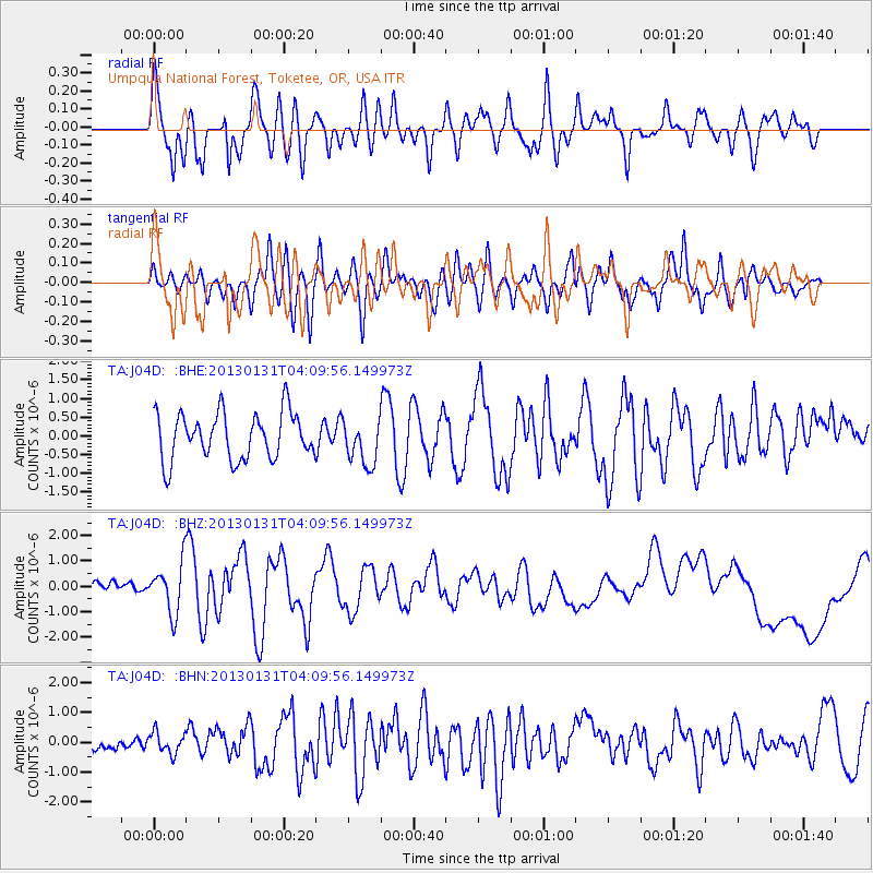
J04D Umpqua National Forest, Toketee, OR, USA - Earthquake Result Viewer
*The percent match for this event was below the threshold and hence no stack was calculated.
| Earthquake location: |
Santa Cruz Islands |
| Earthquake latitude/longitude: |
-10.7/166.4 |
| Earthquake time(UTC): |
2013/01/31 (031) 03:57:56 GMT |
| Earthquake Depth: |
10 km |
| Earthquake Magnitude: |
5.6 MB, 5.9 MS, 5.8 MW |
| Earthquake Catalog/Contributor: |
WHDF/NEIC |
|
| Network: |
TA USArray Transportable Network (new EarthScope stations) |
| Station: |
J04D Umpqua National Forest, Toketee, OR, USA |
| Lat/Lon: |
43.24 N/122.11 W |
| Elevation: |
1948 m |
|
| Distance: |
84.1 deg |
| Az: |
44.162 deg |
| Baz: |
249.562 deg |
| Ray Param: |
$rayparam |
*The percent match for this event was below the threshold and hence was not used in the summary stack. |
|
| Radial Match: |
67.6615 % |
| Radial Bump: |
400 |
| Transverse Match: |
68.15251 % |
| Transverse Bump: |
400 |
| SOD ConfigId: |
494114 |
| Insert Time: |
2013-04-27 05:02:22.692 +0000 |
| GWidth: |
2.5 |
| Max Bumps: |
400 |
| Tol: |
0.001 |
|
Signal To Noise
| Channel | StoN | STA | LTA |
| TA:J04D: :BHZ:20130131T04:09:56.149973Z | 2.4810224 | 9.657434E-7 | 3.892522E-7 |
| TA:J04D: :BHN:20130131T04:09:56.149973Z | 0.7466386 | 3.5262448E-7 | 4.722827E-7 |
| TA:J04D: :BHE:20130131T04:09:56.149973Z | 0.96460015 | 6.01113E-7 | 6.2317326E-7 |
| Arrivals |
| Ps | |
| PpPs | |
| PsPs/PpSs | |


