You are here: Home > Network List > GT - Global Telemetered Seismograph Network (USAF/USGS) Stations List
> Station BDFB Brasilia, Brazil > Earthquake Result Viewer
BDFB Brasilia, Brazil - Earthquake Result Viewer
| Earthquake location: |
Guerrero, Mexico |
| Earthquake latitude/longitude: |
17.6/-101.0 |
| Earthquake time(UTC): |
1996/07/15 (197) 21:23:34 GMT |
| Earthquake Depth: |
18 km |
| Earthquake Magnitude: |
5.7 MB, 6.5 MS, 6.6 UNKNOWN, 6.2 ME |
| Earthquake Catalog/Contributor: |
WHDF/NEIC |
|
| Network: |
GT Global Telemetered Seismograph Network (USAF/USGS) |
| Station: |
BDFB Brasilia, Brazil |
| Lat/Lon: |
15.64 S/48.01 W |
| Elevation: |
1195 m |
|
| Distance: |
61.8 deg |
| Az: |
119.215 deg |
| Baz: |
300.227 deg |
| Ray Param: |
0.060649887 |
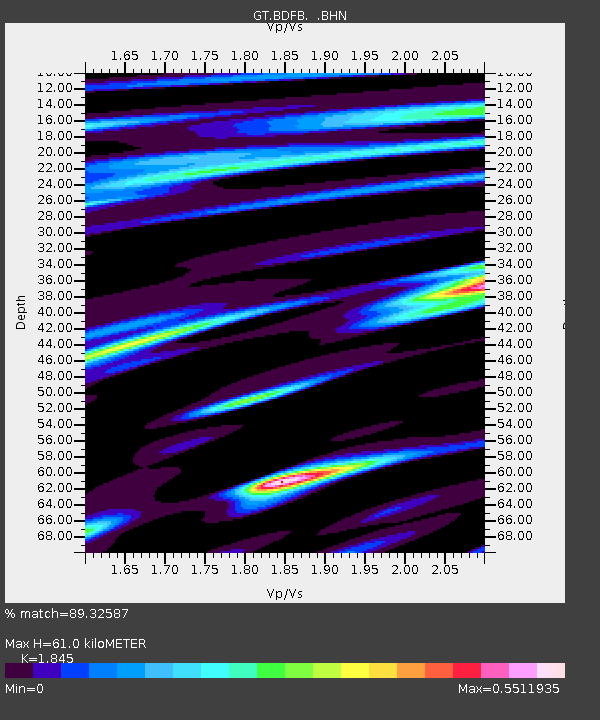
| Estimated Moho Depth: |
61.0 km |
| Estimated Crust Vp/Vs: |
1.85 |
| Assumed Crust Vp: |
6.419 km/s |
| Estimated Crust Vs: |
3.479 km/s |
| Estimated Crust Poisson's Ratio: |
0.29 |
|
| Radial Match: |
89.32587 % |
| Radial Bump: |
343 |
| Transverse Match: |
83.52286 % |
| Transverse Bump: |
400 |
| SOD ConfigId: |
6273 |
| Insert Time: |
2010-02-27 01:36:00.154 +0000 |
| GWidth: |
2.5 |
| Max Bumps: |
400 |
| Tol: |
0.001 |
|
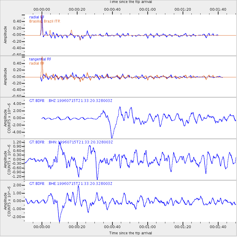
Signal To Noise
| Channel | StoN | STA | LTA |
| GT:BDFB: :BHN:19960715T21:33:20.328003Z | 1.3189726 | 2.425477E-7 | 1.8389139E-7 |
| GT:BDFB: :BHE:19960715T21:33:20.328003Z | 3.5175276 | 4.1017387E-7 | 1.1660857E-7 |
| GT:BDFB: :BHZ:19960715T21:33:20.328003Z | 3.6703093 | 8.1224323E-7 | 2.2130104E-7 |
| Arrivals |
| Ps | 8.4 SECOND |
| PpPs | 26 SECOND |
| PsPs/PpSs | 34 SECOND |


