You are here: Home > Network List > TA - USArray Transportable Network (new EarthScope stations) Stations List
> Station A04D Lummi Island, WA, USA > Earthquake Result Viewer
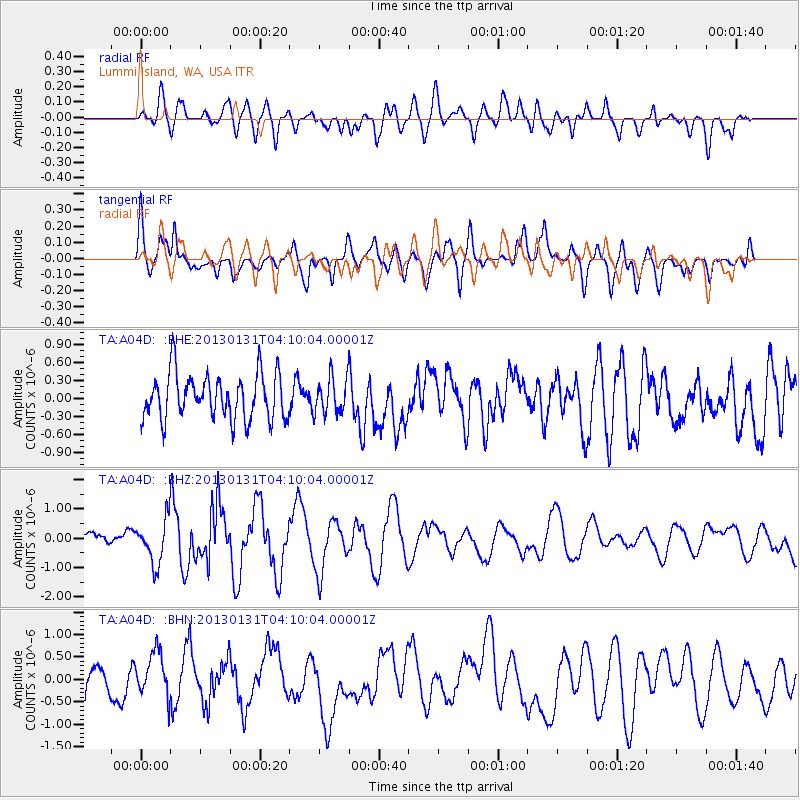
A04D Lummi Island, WA, USA - Earthquake Result Viewer
*The percent match for this event was below the threshold and hence no stack was calculated.
| Earthquake location: |
Santa Cruz Islands |
| Earthquake latitude/longitude: |
-10.7/166.4 |
| Earthquake time(UTC): |
2013/01/31 (031) 03:57:56 GMT |
| Earthquake Depth: |
10 km |
| Earthquake Magnitude: |
5.6 MB, 5.9 MS, 5.8 MW |
| Earthquake Catalog/Contributor: |
WHDF/NEIC |
|
| Network: |
TA USArray Transportable Network (new EarthScope stations) |
| Station: |
A04D Lummi Island, WA, USA |
| Lat/Lon: |
48.72 N/122.71 W |
| Elevation: |
13 m |
|
| Distance: |
85.7 deg |
| Az: |
38.873 deg |
| Baz: |
248.665 deg |
| Ray Param: |
$rayparam |
*The percent match for this event was below the threshold and hence was not used in the summary stack. |
|
| Radial Match: |
50.25492 % |
| Radial Bump: |
400 |
| Transverse Match: |
48.576187 % |
| Transverse Bump: |
400 |
| SOD ConfigId: |
494114 |
| Insert Time: |
2013-04-27 05:03:24.330 +0000 |
| GWidth: |
2.5 |
| Max Bumps: |
400 |
| Tol: |
0.001 |
|
Signal To Noise
| Channel | StoN | STA | LTA |
| TA:A04D: :BHZ:20130131T04:10:04.00001Z | 3.3102868 | 7.425684E-7 | 2.2432145E-7 |
| TA:A04D: :BHN:20130131T04:10:04.00001Z | 1.0794516 | 4.9246063E-7 | 4.5621374E-7 |
| TA:A04D: :BHE:20130131T04:10:04.00001Z | 0.7917102 | 2.9631116E-7 | 3.7426722E-7 |
| Arrivals |
| Ps | |
| PpPs | |
| PsPs/PpSs | |


