You are here: Home > Network List > TA - USArray Transportable Network (new EarthScope stations) Stations List
> Station J01E Myrtle Point, OR, USA > Earthquake Result Viewer
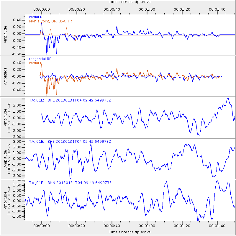
J01E Myrtle Point, OR, USA - Earthquake Result Viewer
*The percent match for this event was below the threshold and hence no stack was calculated.
| Earthquake location: |
Santa Cruz Islands |
| Earthquake latitude/longitude: |
-10.7/166.4 |
| Earthquake time(UTC): |
2013/01/31 (031) 03:57:56 GMT |
| Earthquake Depth: |
10 km |
| Earthquake Magnitude: |
5.6 MB, 5.9 MS, 5.8 MW |
| Earthquake Catalog/Contributor: |
WHDF/NEIC |
|
| Network: |
TA USArray Transportable Network (new EarthScope stations) |
| Station: |
J01E Myrtle Point, OR, USA |
| Lat/Lon: |
43.16 N/123.93 W |
| Elevation: |
128 m |
|
| Distance: |
82.9 deg |
| Az: |
43.754 deg |
| Baz: |
248.273 deg |
| Ray Param: |
$rayparam |
*The percent match for this event was below the threshold and hence was not used in the summary stack. |
|
| Radial Match: |
88.84806 % |
| Radial Bump: |
364 |
| Transverse Match: |
50.6985 % |
| Transverse Bump: |
400 |
| SOD ConfigId: |
494114 |
| Insert Time: |
2013-04-27 05:04:07.108 +0000 |
| GWidth: |
2.5 |
| Max Bumps: |
400 |
| Tol: |
0.001 |
|
Signal To Noise
| Channel | StoN | STA | LTA |
| TA:J01E: :BHZ:20130131T04:09:49.649973Z | 2.232714 | 1.1390309E-6 | 5.101553E-7 |
| TA:J01E: :BHN:20130131T04:09:49.649973Z | 1.5847684 | 7.51841E-7 | 4.7441696E-7 |
| TA:J01E: :BHE:20130131T04:09:49.649973Z | 1.6126362 | 8.6848644E-7 | 5.3855075E-7 |
| Arrivals |
| Ps | |
| PpPs | |
| PsPs/PpSs | |


