You are here: Home > Network List > UW - Pacific Northwest Regional Seismic Network Stations List
> Station MRBL Marblemount, WA, USA > Earthquake Result Viewer
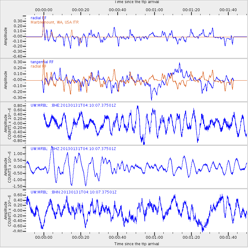
MRBL Marblemount, WA, USA - Earthquake Result Viewer
*The percent match for this event was below the threshold and hence no stack was calculated.
| Earthquake location: |
Santa Cruz Islands |
| Earthquake latitude/longitude: |
-10.7/166.4 |
| Earthquake time(UTC): |
2013/01/31 (031) 03:57:56 GMT |
| Earthquake Depth: |
10 km |
| Earthquake Magnitude: |
5.6 MB, 5.9 MS, 5.8 MW |
| Earthquake Catalog/Contributor: |
WHDF/NEIC |
|
| Network: |
UW Pacific Northwest Regional Seismic Network |
| Station: |
MRBL Marblemount, WA, USA |
| Lat/Lon: |
48.52 N/121.48 W |
| Elevation: |
75 m |
|
| Distance: |
86.4 deg |
| Az: |
39.351 deg |
| Baz: |
249.613 deg |
| Ray Param: |
$rayparam |
*The percent match for this event was below the threshold and hence was not used in the summary stack. |
|
| Radial Match: |
61.146236 % |
| Radial Bump: |
400 |
| Transverse Match: |
67.62497 % |
| Transverse Bump: |
400 |
| SOD ConfigId: |
494114 |
| Insert Time: |
2013-04-27 05:04:59.091 +0000 |
| GWidth: |
2.5 |
| Max Bumps: |
400 |
| Tol: |
0.001 |
|
Signal To Noise
| Channel | StoN | STA | LTA |
| UW:MRBL: :BHZ:20130131T04:10:07.37501Z | 3.3516958 | 7.041323E-7 | 2.100824E-7 |
| UW:MRBL: :BHN:20130131T04:10:07.37501Z | 1.4715346 | 3.5551162E-7 | 2.4159243E-7 |
| UW:MRBL: :BHE:20130131T04:10:07.37501Z | 1.1197854 | 3.0521542E-7 | 2.7256598E-7 |
| Arrivals |
| Ps | |
| PpPs | |
| PsPs/PpSs | |


