You are here: Home > Network List > UW - Pacific Northwest Regional Seismic Network Stations List
> Station UMAT Pilot Rock, OR, USA > Earthquake Result Viewer
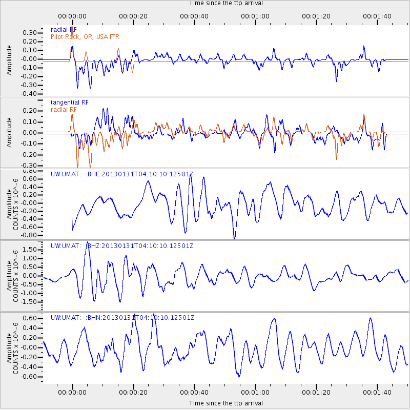
UMAT Pilot Rock, OR, USA - Earthquake Result Viewer
*The percent match for this event was below the threshold and hence no stack was calculated.
| Earthquake location: |
Santa Cruz Islands |
| Earthquake latitude/longitude: |
-10.7/166.4 |
| Earthquake time(UTC): |
2013/01/31 (031) 03:57:56 GMT |
| Earthquake Depth: |
10 km |
| Earthquake Magnitude: |
5.6 MB, 5.9 MS, 5.8 MW |
| Earthquake Catalog/Contributor: |
WHDF/NEIC |
|
| Network: |
UW Pacific Northwest Regional Seismic Network |
| Station: |
UMAT Pilot Rock, OR, USA |
| Lat/Lon: |
45.29 N/118.96 W |
| Elevation: |
1318 m |
|
| Distance: |
87.0 deg |
| Az: |
42.977 deg |
| Baz: |
251.662 deg |
| Ray Param: |
$rayparam |
*The percent match for this event was below the threshold and hence was not used in the summary stack. |
|
| Radial Match: |
80.32442 % |
| Radial Bump: |
400 |
| Transverse Match: |
64.103226 % |
| Transverse Bump: |
400 |
| SOD ConfigId: |
494114 |
| Insert Time: |
2013-04-27 05:05:10.713 +0000 |
| GWidth: |
2.5 |
| Max Bumps: |
400 |
| Tol: |
0.001 |
|
Signal To Noise
| Channel | StoN | STA | LTA |
| UW:UMAT: :BHZ:20130131T04:10:10.12501Z | 4.598252 | 8.3053055E-7 | 1.8061877E-7 |
| UW:UMAT: :BHN:20130131T04:10:10.12501Z | 1.2158355 | 2.7196305E-7 | 2.2368408E-7 |
| UW:UMAT: :BHE:20130131T04:10:10.12501Z | 1.3192325 | 3.049816E-7 | 2.3118109E-7 |
| Arrivals |
| Ps | |
| PpPs | |
| PsPs/PpSs | |


