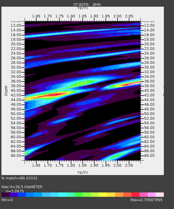
BDFB Brasilia, Brazil - Earthquake Result Viewer

Earthquake location: Off Coast Of Jalisco, Mexico
Earthquake latitude/longitude: 19.0/-107.3
Earthquake time(UTC): 1997/05/01 (121) 11:37:36 GMT
Earthquake Depth: 33 km
Earthquake Magnitude: 6.1 MB, 6.8 MS, 7.1 UNKNOWN, 7.1 ME
Earthquake Catalog/Contributor: WHDF/NEIC
Network: GT Global Telemetered Seismograph Network (USAF/USGS)
Station: BDFB Brasilia, Brazil
Lat/Lon: 15.64 S/48.01 W
Elevation: 1195 m
Distance: 67.8 deg
Az: 116.462 deg
Baz: 298.449 deg
Ray Param: 0.056686446
Estimated Moho Depth: 36.5 km
Estimated Crust Vp/Vs: 2.10
Assumed Crust Vp: 6.419 km/s
Estimated Crust Vs: 3.06 km/s
Estimated Crust Poisson's Ratio: 0.35
Radial Match: 98.43332 %
Radial Bump: 241
Transverse Match: 91.27342 %
Transverse Bump: 400
SOD ConfigId: 6273
Insert Time: 2010-02-27 01:36:05.778 +0000
GWidth: 2.5
Max Bumps: 400
Tol: 0.001

Signal To Noise

ChannelStoNSTALTA
GT:BDFB: :BHN:19970501T11:47:59.727014Z5.90582236.0885986E-71.03094855E-7
GT:BDFB: :BHE:19970501T11:47:59.727014Z9.0397861.1801311E-61.3054856E-7
GT:BDFB: :BHZ:19970501T11:47:59.727014Z16.3810022.4462586E-61.493351E-7
Arrivals
Ps6.4 SECOND
PpPs17 SECOND
PsPs/PpSs23 SECOND