You are here: Home > Network List > GT - Global Telemetered Seismograph Network (USAF/USGS) Stations List
> Station BDFB Brasilia, Brazil > Earthquake Result Viewer
BDFB Brasilia, Brazil - Earthquake Result Viewer
| Earthquake location: |
Guerrero, Mexico |
| Earthquake latitude/longitude: |
18.7/-101.6 |
| Earthquake time(UTC): |
1997/05/22 (142) 07:50:53 GMT |
| Earthquake Depth: |
70 km |
| Earthquake Magnitude: |
5.9 MB, 6.0 MS, 6.6 UNKNOWN, 6.5 MW |
| Earthquake Catalog/Contributor: |
WHDF/NEIC |
|
| Network: |
GT Global Telemetered Seismograph Network (USAF/USGS) |
| Station: |
BDFB Brasilia, Brazil |
| Lat/Lon: |
15.64 S/48.01 W |
| Elevation: |
1195 m |
|
| Distance: |
62.8 deg |
| Az: |
119.355 deg |
| Baz: |
300.953 deg |
| Ray Param: |
0.059804026 |
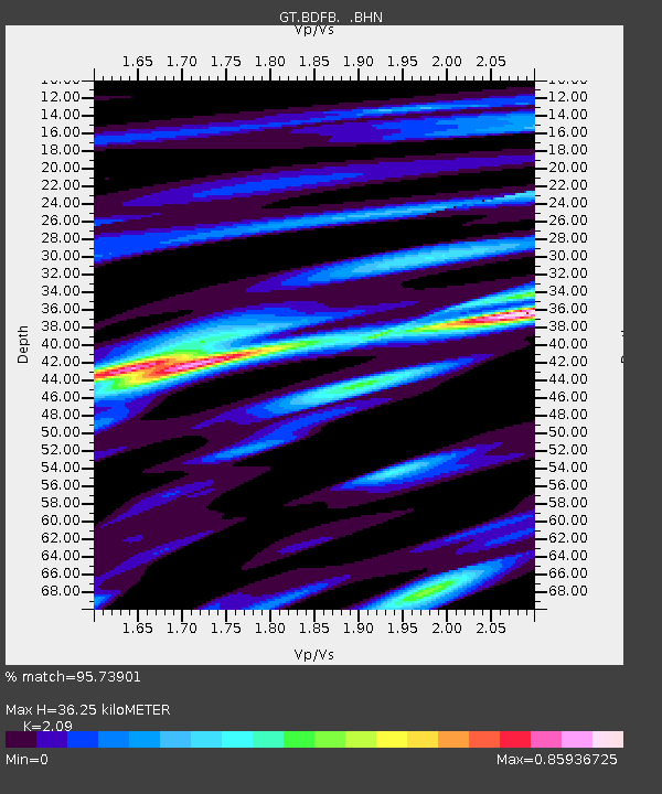
| Estimated Moho Depth: |
36.25 km |
| Estimated Crust Vp/Vs: |
2.09 |
| Assumed Crust Vp: |
6.419 km/s |
| Estimated Crust Vs: |
3.071 km/s |
| Estimated Crust Poisson's Ratio: |
0.35 |
|
| Radial Match: |
95.73901 % |
| Radial Bump: |
266 |
| Transverse Match: |
86.7686 % |
| Transverse Bump: |
400 |
| SOD ConfigId: |
6273 |
| Insert Time: |
2010-02-27 01:36:07.214 +0000 |
| GWidth: |
2.5 |
| Max Bumps: |
400 |
| Tol: |
0.001 |
|

Signal To Noise
| Channel | StoN | STA | LTA |
| GT:BDFB: :BHN:19970522T08:00:41.090027Z | 9.26411 | 8.0022966E-7 | 8.637955E-8 |
| GT:BDFB: :BHE:19970522T08:00:41.090027Z | 8.221248 | 1.6455597E-6 | 2.0015936E-7 |
| GT:BDFB: :BHZ:19970522T08:00:41.090027Z | 29.149439 | 3.1480015E-6 | 1.0799527E-7 |
| Arrivals |
| Ps | 6.4 SECOND |
| PpPs | 17 SECOND |
| PsPs/PpSs | 23 SECOND |


