You are here: Home > Network List > TA - USArray Transportable Network (new EarthScope stations) Stations List
> Station O03E Paynes Creek, CA, USA > Earthquake Result Viewer
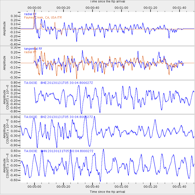
O03E Paynes Creek, CA, USA - Earthquake Result Viewer
*The percent match for this event was below the threshold and hence no stack was calculated.
| Earthquake location: |
Santa Cruz Islands |
| Earthquake latitude/longitude: |
-10.6/166.4 |
| Earthquake time(UTC): |
2013/01/31 (031) 05:18:09 GMT |
| Earthquake Depth: |
10 km |
| Earthquake Magnitude: |
5.5 MW, 5.4 MB |
| Earthquake Catalog/Contributor: |
WHDF/NEIC |
|
| Network: |
TA USArray Transportable Network (new EarthScope stations) |
| Station: |
O03E Paynes Creek, CA, USA |
| Lat/Lon: |
40.29 N/121.80 W |
| Elevation: |
967 m |
|
| Distance: |
83.3 deg |
| Az: |
47.034 deg |
| Baz: |
250.159 deg |
| Ray Param: |
$rayparam |
*The percent match for this event was below the threshold and hence was not used in the summary stack. |
|
| Radial Match: |
59.813484 % |
| Radial Bump: |
400 |
| Transverse Match: |
70.22505 % |
| Transverse Bump: |
400 |
| SOD ConfigId: |
494114 |
| Insert Time: |
2013-04-27 05:15:06.851 +0000 |
| GWidth: |
2.5 |
| Max Bumps: |
400 |
| Tol: |
0.001 |
|
Signal To Noise
| Channel | StoN | STA | LTA |
| TA:O03E: :BHZ:20130131T05:30:04.800027Z | 2.0755486 | 5.8376463E-7 | 2.8125797E-7 |
| TA:O03E: :BHN:20130131T05:30:04.800027Z | 1.4084362 | 3.0384223E-7 | 2.157302E-7 |
| TA:O03E: :BHE:20130131T05:30:04.800027Z | 2.2915735 | 4.992642E-7 | 2.178696E-7 |
| Arrivals |
| Ps | |
| PpPs | |
| PsPs/PpSs | |


