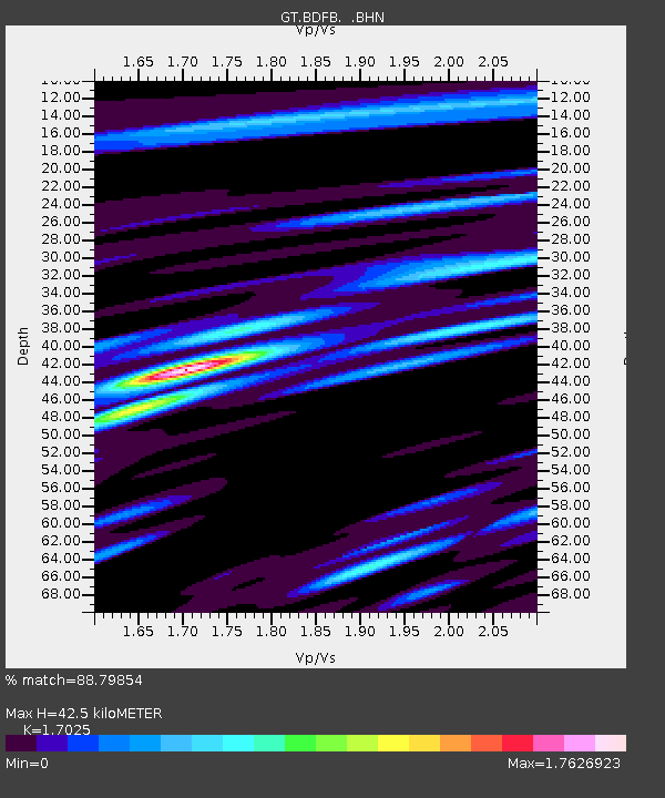
BDFB Brasilia, Brazil - Earthquake Result Viewer

Earthquake location: South Sandwich Islands Region
Earthquake latitude/longitude: -59.7/-29.2
Earthquake time(UTC): 1997/10/05 (278) 18:04:30 GMT
Earthquake Depth: 274 km
Earthquake Magnitude: 6.0 MB, 6.3 UNKNOWN, 6.3 MW
Earthquake Catalog/Contributor: WHDF/NEIC
Network: GT Global Telemetered Seismograph Network (USAF/USGS)
Station: BDFB Brasilia, Brazil
Lat/Lon: 15.64 S/48.01 W
Elevation: 1195 m
Distance: 46.1 deg
Az: 334.47 deg
Baz: 166.905 deg
Ray Param: 0.06973366
Estimated Moho Depth: 42.5 km
Estimated Crust Vp/Vs: 1.70
Assumed Crust Vp: 6.419 km/s
Estimated Crust Vs: 3.77 km/s
Estimated Crust Poisson's Ratio: 0.24
Radial Match: 88.79854 %
Radial Bump: 400
Transverse Match: 78.01471 %
Transverse Bump: 400
SOD ConfigId: 6273
Insert Time: 2010-02-27 01:36:14.946 +0000
GWidth: 2.5
Max Bumps: 400
Tol: 0.001

Signal To Noise

ChannelStoNSTALTA
GT:BDFB: :BHN:19971005T18:11:56.838989Z7.4825082.0219334E-62.7022134E-7
GT:BDFB: :BHE:19971005T18:11:56.838989Z2.44007065.9423974E-72.4353383E-7
GT:BDFB: :BHZ:19971005T18:11:56.838989Z14.8027633.640741E-62.459501E-7
Arrivals
Ps5.0 SECOND
PpPs17 SECOND
PsPs/PpSs22 SECOND