You are here: Home > Network List > TA - USArray Transportable Network (new EarthScope stations) Stations List
> Station Z48A Northport, AL, USA > Earthquake Result Viewer
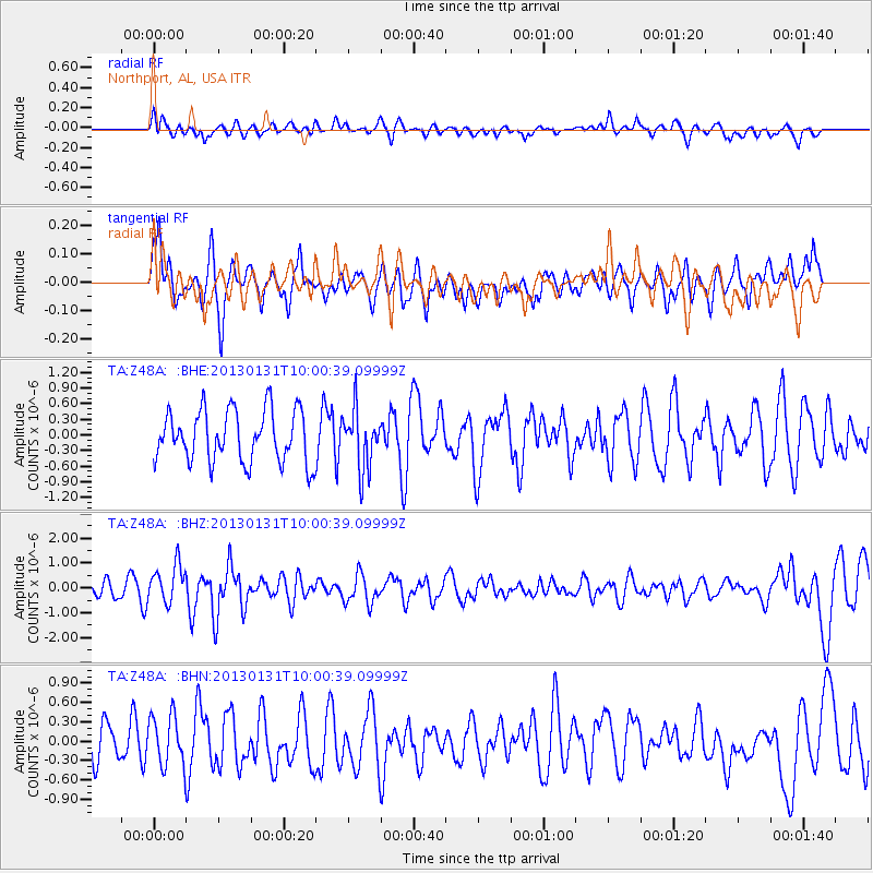
Z48A Northport, AL, USA - Earthquake Result Viewer
*The percent match for this event was below the threshold and hence no stack was calculated.
| Earthquake location: |
Off Coast Of Southeastern Alaska |
| Earthquake latitude/longitude: |
55.4/-135.0 |
| Earthquake time(UTC): |
2013/01/31 (031) 09:53:40 GMT |
| Earthquake Depth: |
13 km |
| Earthquake Magnitude: |
5.6 MB, 5.7 MS, 5.9 MW, 5.9 MW |
| Earthquake Catalog/Contributor: |
WHDF/NEIC |
|
| Network: |
TA USArray Transportable Network (new EarthScope stations) |
| Station: |
Z48A Northport, AL, USA |
| Lat/Lon: |
33.38 N/87.56 W |
| Elevation: |
101 m |
|
| Distance: |
39.4 deg |
| Az: |
103.917 deg |
| Baz: |
318.615 deg |
| Ray Param: |
$rayparam |
*The percent match for this event was below the threshold and hence was not used in the summary stack. |
|
| Radial Match: |
44.626984 % |
| Radial Bump: |
400 |
| Transverse Match: |
49.80101 % |
| Transverse Bump: |
400 |
| SOD ConfigId: |
494114 |
| Insert Time: |
2013-04-27 05:20:00.537 +0000 |
| GWidth: |
2.5 |
| Max Bumps: |
400 |
| Tol: |
0.001 |
|
Signal To Noise
| Channel | StoN | STA | LTA |
| TA:Z48A: :BHZ:20130131T10:00:39.09999Z | 2.7726715 | 7.64544E-7 | 2.7574274E-7 |
| TA:Z48A: :BHN:20130131T10:00:39.09999Z | 1.5419124 | 3.9273536E-7 | 2.5470666E-7 |
| TA:Z48A: :BHE:20130131T10:00:39.09999Z | 1.1216263 | 5.5739E-7 | 4.969481E-7 |
| Arrivals |
| Ps | |
| PpPs | |
| PsPs/PpSs | |


