You are here: Home > Network List > TA - USArray Transportable Network (new EarthScope stations) Stations List
> Station O41A Passley's Farm, La Prairie, IL, USA > Earthquake Result Viewer
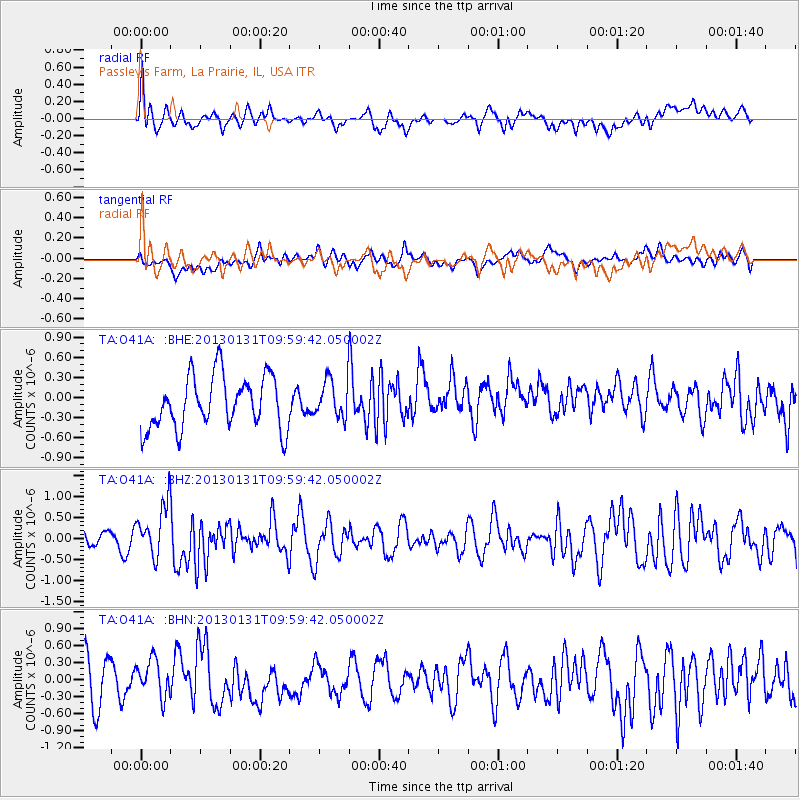
O41A Passley's Farm, La Prairie, IL, USA - Earthquake Result Viewer
*The percent match for this event was below the threshold and hence no stack was calculated.
| Earthquake location: |
Off Coast Of Southeastern Alaska |
| Earthquake latitude/longitude: |
55.4/-135.0 |
| Earthquake time(UTC): |
2013/01/31 (031) 09:53:40 GMT |
| Earthquake Depth: |
13 km |
| Earthquake Magnitude: |
5.6 MB, 5.7 MS, 5.9 MW, 5.9 MW |
| Earthquake Catalog/Contributor: |
WHDF/NEIC |
|
| Network: |
TA USArray Transportable Network (new EarthScope stations) |
| Station: |
O41A Passley's Farm, La Prairie, IL, USA |
| Lat/Lon: |
40.12 N/90.88 W |
| Elevation: |
203 m |
|
| Distance: |
32.8 deg |
| Az: |
99.197 deg |
| Baz: |
312.809 deg |
| Ray Param: |
$rayparam |
*The percent match for this event was below the threshold and hence was not used in the summary stack. |
|
| Radial Match: |
45.95958 % |
| Radial Bump: |
400 |
| Transverse Match: |
37.023815 % |
| Transverse Bump: |
400 |
| SOD ConfigId: |
494114 |
| Insert Time: |
2013-04-27 05:20:28.497 +0000 |
| GWidth: |
2.5 |
| Max Bumps: |
400 |
| Tol: |
0.001 |
|
Signal To Noise
| Channel | StoN | STA | LTA |
| TA:O41A: :BHZ:20130131T09:59:42.050002Z | 3.2969017 | 6.238311E-7 | 1.8921739E-7 |
| TA:O41A: :BHN:20130131T09:59:42.050002Z | 0.74550444 | 3.3695537E-7 | 4.5198306E-7 |
| TA:O41A: :BHE:20130131T09:59:42.050002Z | 0.73868585 | 2.884969E-7 | 3.9055422E-7 |
| Arrivals |
| Ps | |
| PpPs | |
| PsPs/PpSs | |


