You are here: Home > Network List > TA - USArray Transportable Network (new EarthScope stations) Stations List
> Station R41A Rosebud, MO, USA > Earthquake Result Viewer
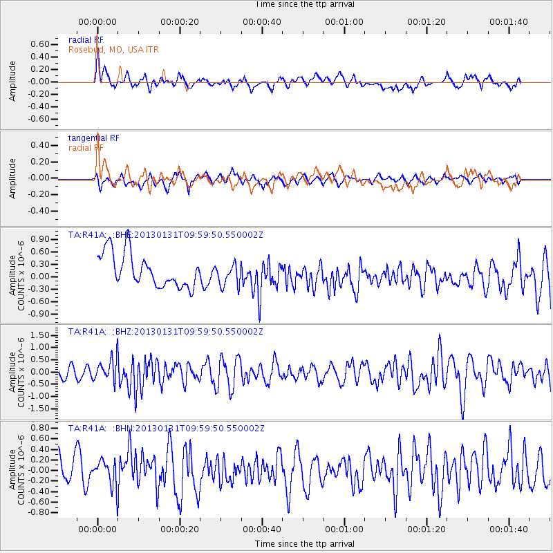
R41A Rosebud, MO, USA - Earthquake Result Viewer
*The percent match for this event was below the threshold and hence no stack was calculated.
| Earthquake location: |
Off Coast Of Southeastern Alaska |
| Earthquake latitude/longitude: |
55.4/-135.0 |
| Earthquake time(UTC): |
2013/01/31 (031) 09:53:40 GMT |
| Earthquake Depth: |
13 km |
| Earthquake Magnitude: |
5.6 MB, 5.7 MS, 5.9 MW, 5.9 MW |
| Earthquake Catalog/Contributor: |
WHDF/NEIC |
|
| Network: |
TA USArray Transportable Network (new EarthScope stations) |
| Station: |
R41A Rosebud, MO, USA |
| Lat/Lon: |
38.30 N/91.38 W |
| Elevation: |
257 m |
|
| Distance: |
33.7 deg |
| Az: |
102.074 deg |
| Baz: |
314.902 deg |
| Ray Param: |
$rayparam |
*The percent match for this event was below the threshold and hence was not used in the summary stack. |
|
| Radial Match: |
52.359215 % |
| Radial Bump: |
400 |
| Transverse Match: |
53.66517 % |
| Transverse Bump: |
400 |
| SOD ConfigId: |
494114 |
| Insert Time: |
2013-04-27 05:20:43.992 +0000 |
| GWidth: |
2.5 |
| Max Bumps: |
400 |
| Tol: |
0.001 |
|
Signal To Noise
| Channel | StoN | STA | LTA |
| TA:R41A: :BHZ:20130131T09:59:50.550002Z | 2.2476928 | 4.6587394E-7 | 2.0726762E-7 |
| TA:R41A: :BHN:20130131T09:59:50.550002Z | 1.0032847 | 2.6495997E-7 | 2.640925E-7 |
| TA:R41A: :BHE:20130131T09:59:50.550002Z | 0.689614 | 2.8102428E-7 | 4.0750956E-7 |
| Arrivals |
| Ps | |
| PpPs | |
| PsPs/PpSs | |


