You are here: Home > Network List > XD14 - Illuminating the architecture of the greater Mount St. Helens magmatic systems f Stations List
> Station ME06 "Mount St Helens, WA" > Earthquake Result Viewer
ME06 "Mount St Helens, WA" - Earthquake Result Viewer
| Earthquake location: |
Volcano Islands, Japan Region |
| Earthquake latitude/longitude: |
24.4/142.6 |
| Earthquake time(UTC): |
2014/06/29 (180) 05:56:31 GMT |
| Earthquake Depth: |
43 km |
| Earthquake Magnitude: |
6.2 MWP |
| Earthquake Catalog/Contributor: |
NEIC PDE/NEIC COMCAT |
|
| Network: |
XD Illuminating the architecture of the greater Mount St. Helens magmatic systems f |
| Station: |
ME06 "Mount St Helens, WA" |
| Lat/Lon: |
46.46 N/122.20 W |
| Elevation: |
643 m |
|
| Distance: |
76.1 deg |
| Az: |
45.157 deg |
| Baz: |
290.742 deg |
| Ray Param: |
0.05112337 |
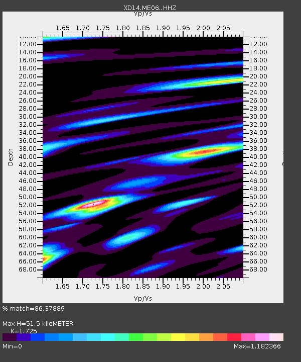
| Estimated Moho Depth: |
51.5 km |
| Estimated Crust Vp/Vs: |
1.73 |
| Assumed Crust Vp: |
6.566 km/s |
| Estimated Crust Vs: |
3.806 km/s |
| Estimated Crust Poisson's Ratio: |
0.25 |
|
| Radial Match: |
86.37889 % |
| Radial Bump: |
400 |
| Transverse Match: |
67.01485 % |
| Transverse Bump: |
400 |
| SOD ConfigId: |
3390531 |
| Insert Time: |
2019-04-12 13:57:24.732 +0000 |
| GWidth: |
2.5 |
| Max Bumps: |
400 |
| Tol: |
0.001 |
|

Signal To Noise
| Channel | StoN | STA | LTA |
| XD:ME06: :HHZ:20140629T06:07:42.964976Z | 6.1357493 | 1.2987423E-6 | 2.1166808E-7 |
| XD:ME06: :HHN:20140629T06:07:42.964976Z | 3.1133492 | 7.0228987E-7 | 2.2557376E-7 |
| XD:ME06: :HHE:20140629T06:07:42.964976Z | 1.8750261 | 5.248994E-7 | 2.7994244E-7 |
| Arrivals |
| Ps | 5.9 SECOND |
| PpPs | 21 SECOND |
| PsPs/PpSs | 27 SECOND |


