You are here: Home > Network List > GT - Global Telemetered Seismograph Network (USAF/USGS) Stations List
> Station BDFB Brasilia, Brazil > Earthquake Result Viewer
BDFB Brasilia, Brazil - Earthquake Result Viewer
| Earthquake location: |
Azores Islands, Portugal |
| Earthquake latitude/longitude: |
38.7/-28.6 |
| Earthquake time(UTC): |
1998/07/09 (190) 05:19:07 GMT |
| Earthquake Depth: |
10 km |
| Earthquake Magnitude: |
5.7 MB, 6.0 MS, 6.6 UNKNOWN, 6.2 MW |
| Earthquake Catalog/Contributor: |
WHDF/NEIC |
|
| Network: |
GT Global Telemetered Seismograph Network (USAF/USGS) |
| Station: |
BDFB Brasilia, Brazil |
| Lat/Lon: |
15.64 S/48.01 W |
| Elevation: |
1195 m |
|
| Distance: |
57.0 deg |
| Az: |
202.424 deg |
| Baz: |
18.06 deg |
| Ray Param: |
0.06378682 |
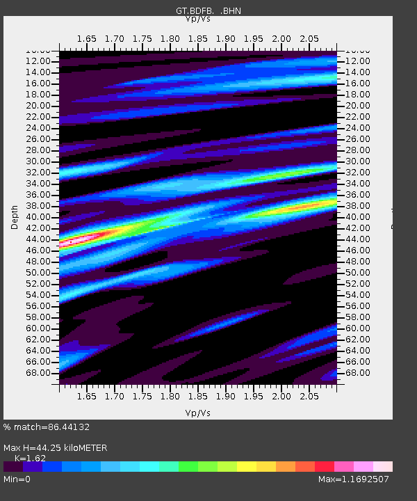
| Estimated Moho Depth: |
44.25 km |
| Estimated Crust Vp/Vs: |
1.62 |
| Assumed Crust Vp: |
6.419 km/s |
| Estimated Crust Vs: |
3.962 km/s |
| Estimated Crust Poisson's Ratio: |
0.19 |
|
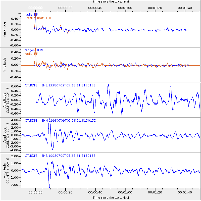
| Radial Match: |
86.44132 % |
| Radial Bump: |
400 |
| Transverse Match: |
67.46008 % |
| Transverse Bump: |
400 |
| SOD ConfigId: |
4480 |
| Insert Time: |
2010-02-27 01:36:24.154 +0000 |
| GWidth: |
2.5 |
| Max Bumps: |
400 |
| Tol: |
0.001 |
|
Signal To Noise
| Channel | StoN | STA | LTA |
| GT:BDFB: :BHN:19980709T05:28:21.815015Z | 1.8136765 | 3.3759545E-7 | 1.8613873E-7 |
| GT:BDFB: :BHE:19980709T05:28:21.815015Z | 1.7609439 | 2.4563994E-7 | 1.3949334E-7 |
| GT:BDFB: :BHZ:19980709T05:28:21.815015Z | 1.3007159 | 1.7398393E-7 | 1.3376014E-7 |
| Arrivals |
| Ps | 4.5 SECOND |
| PpPs | 17 SECOND |
| PsPs/PpSs | 22 SECOND |


