You are here: Home > Network List > GT - Global Telemetered Seismograph Network (USAF/USGS) Stations List
> Station BDFB Brasilia, Brazil > Earthquake Result Viewer
BDFB Brasilia, Brazil - Earthquake Result Viewer
| Earthquake location: |
Near Coast Of Ecuador |
| Earthquake latitude/longitude: |
-0.6/-80.4 |
| Earthquake time(UTC): |
1998/08/04 (216) 18:59:20 GMT |
| Earthquake Depth: |
33 km |
| Earthquake Magnitude: |
6.2 MB, 7.1 MS, 7.1 UNKNOWN, 7.0 ME |
| Earthquake Catalog/Contributor: |
WHDF/NEIC |
|
| Network: |
GT Global Telemetered Seismograph Network (USAF/USGS) |
| Station: |
BDFB Brasilia, Brazil |
| Lat/Lon: |
15.64 S/48.01 W |
| Elevation: |
1195 m |
|
| Distance: |
35.3 deg |
| Az: |
116.708 deg |
| Baz: |
292.002 deg |
| Ray Param: |
0.07724858 |
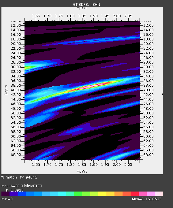
| Estimated Moho Depth: |
38.0 km |
| Estimated Crust Vp/Vs: |
1.89 |
| Assumed Crust Vp: |
6.419 km/s |
| Estimated Crust Vs: |
3.392 km/s |
| Estimated Crust Poisson's Ratio: |
0.31 |
|
| Radial Match: |
94.94645 % |
| Radial Bump: |
288 |
| Transverse Match: |
83.30436 % |
| Transverse Bump: |
400 |
| SOD ConfigId: |
4480 |
| Insert Time: |
2010-02-27 01:36:26.480 +0000 |
| GWidth: |
2.5 |
| Max Bumps: |
400 |
| Tol: |
0.001 |
|
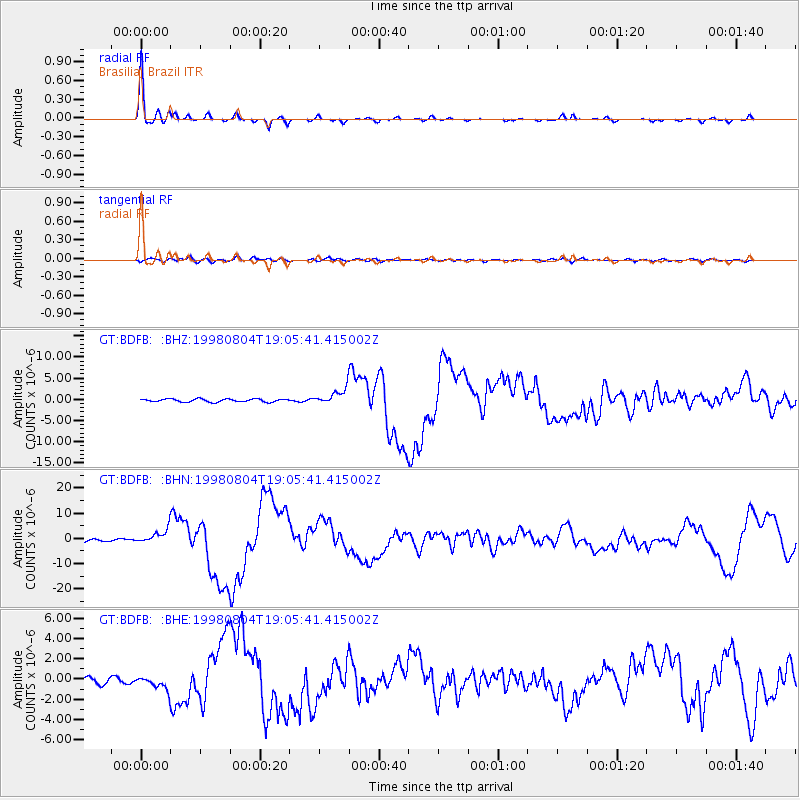
Signal To Noise
| Channel | StoN | STA | LTA |
| GT:BDFB: :BHN:19980804T19:05:41.415002Z | 6.812339 | 2.794329E-6 | 4.1018643E-7 |
| GT:BDFB: :BHE:19980804T19:05:41.415002Z | 2.300637 | 6.1088645E-7 | 2.6552925E-7 |
| GT:BDFB: :BHZ:19980804T19:05:41.415002Z | 5.230036 | 1.8097571E-6 | 3.4603147E-7 |
| Arrivals |
| Ps | 5.7 SECOND |
| PpPs | 16 SECOND |
| PsPs/PpSs | 22 SECOND |


