You are here: Home > Network List > UW - Pacific Northwest Regional Seismic Network Stations List
> Station LON Longmire (broad-band and DWWSSN) > Earthquake Result Viewer
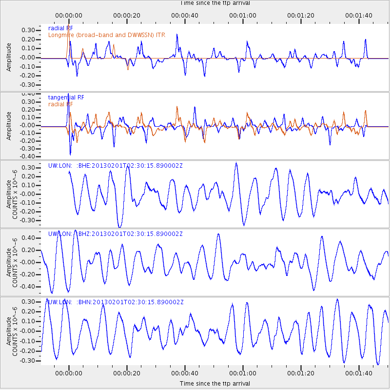
LON Longmire (broad-band and DWWSSN) - Earthquake Result Viewer
*The percent match for this event was below the threshold and hence no stack was calculated.
| Earthquake location: |
Eastern New Guinea Reg., P.N.G. |
| Earthquake latitude/longitude: |
-7.0/147.7 |
| Earthquake time(UTC): |
2013/02/01 (032) 02:17:27 GMT |
| Earthquake Depth: |
44 km |
| Earthquake Magnitude: |
6.0 MS, 5.2 MB, 5.8 MW, 5.8 MW |
| Earthquake Catalog/Contributor: |
WHDF/NEIC |
|
| Network: |
UW Pacific Northwest Regional Seismic Network |
| Station: |
LON Longmire (broad-band and DWWSSN) |
| Lat/Lon: |
46.75 N/121.81 W |
| Elevation: |
850 m |
|
| Distance: |
95.4 deg |
| Az: |
43.679 deg |
| Baz: |
265.606 deg |
| Ray Param: |
$rayparam |
*The percent match for this event was below the threshold and hence was not used in the summary stack. |
|
| Radial Match: |
56.692112 % |
| Radial Bump: |
400 |
| Transverse Match: |
53.96337 % |
| Transverse Bump: |
400 |
| SOD ConfigId: |
494114 |
| Insert Time: |
2013-04-27 05:28:00.649 +0000 |
| GWidth: |
2.5 |
| Max Bumps: |
400 |
| Tol: |
0.001 |
|
Signal To Noise
| Channel | StoN | STA | LTA |
| UW:LON: :BHZ:20130201T02:30:15.890002Z | 1.889806 | 3.5643168E-7 | 1.8860754E-7 |
| UW:LON: :BHN:20130201T02:30:15.890002Z | 0.95296425 | 1.6484702E-7 | 1.7298343E-7 |
| UW:LON: :BHE:20130201T02:30:15.890002Z | 0.52828103 | 9.195814E-8 | 1.740705E-7 |
| Arrivals |
| Ps | |
| PpPs | |
| PsPs/PpSs | |


