You are here: Home > Network List > GT - Global Telemetered Seismograph Network (USAF/USGS) Stations List
> Station BDFB Brasilia, Brazil > Earthquake Result Viewer
BDFB Brasilia, Brazil - Earthquake Result Viewer
| Earthquake location: |
Azores Islands, Portugal |
| Earthquake latitude/longitude: |
38.3/-26.7 |
| Earthquake time(UTC): |
1997/06/27 (178) 04:39:52 GMT |
| Earthquake Depth: |
10 km |
| Earthquake Magnitude: |
5.6 MB, 5.4 MS, 5.9 UNKNOWN, 5.9 MW |
| Earthquake Catalog/Contributor: |
WHDF/NEIC |
|
| Network: |
GT Global Telemetered Seismograph Network (USAF/USGS) |
| Station: |
BDFB Brasilia, Brazil |
| Lat/Lon: |
15.64 S/48.01 W |
| Elevation: |
1195 m |
|
| Distance: |
57.3 deg |
| Az: |
204.611 deg |
| Baz: |
19.874 deg |
| Ray Param: |
0.063579634 |
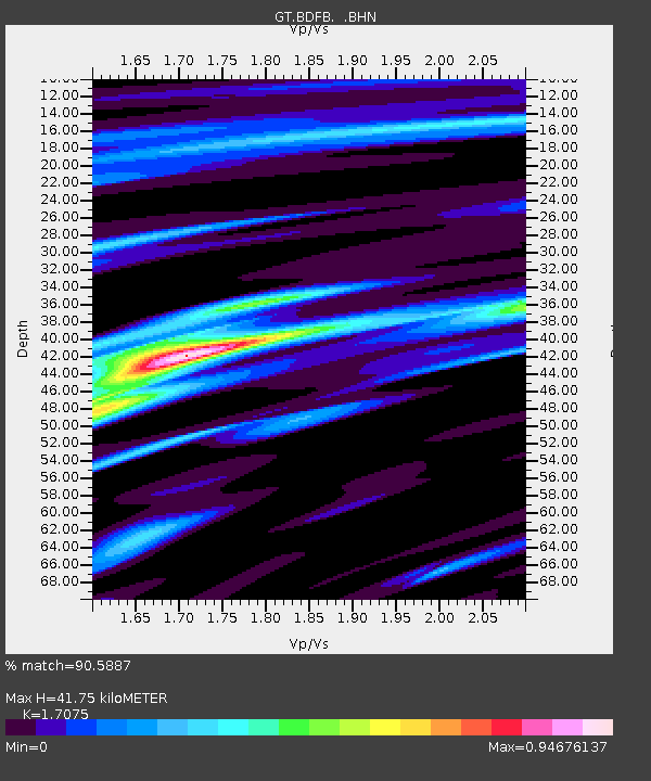
| Estimated Moho Depth: |
41.75 km |
| Estimated Crust Vp/Vs: |
1.71 |
| Assumed Crust Vp: |
6.419 km/s |
| Estimated Crust Vs: |
3.759 km/s |
| Estimated Crust Poisson's Ratio: |
0.24 |
|
| Radial Match: |
90.5887 % |
| Radial Bump: |
332 |
| Transverse Match: |
76.73055 % |
| Transverse Bump: |
400 |
| SOD ConfigId: |
4480 |
| Insert Time: |
2010-02-27 01:36:30.092 +0000 |
| GWidth: |
2.5 |
| Max Bumps: |
400 |
| Tol: |
0.001 |
|
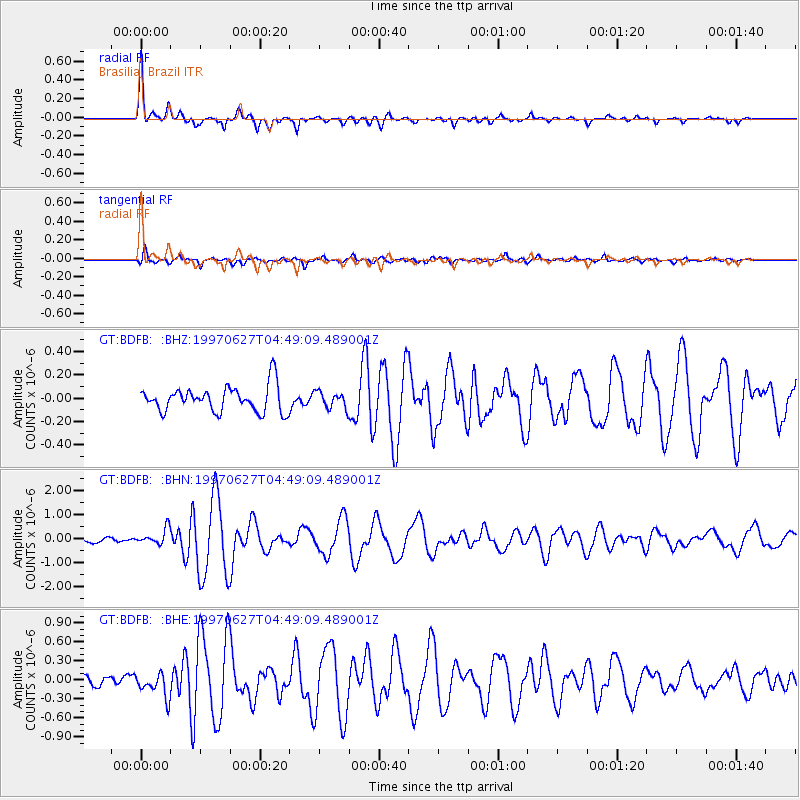
Signal To Noise
| Channel | StoN | STA | LTA |
| GT:BDFB: :BHN:19970627T04:49:09.489001Z | 2.8888116 | 3.273716E-7 | 1.1332396E-7 |
| GT:BDFB: :BHE:19970627T04:49:09.489001Z | 2.182961 | 1.9368038E-7 | 8.87237E-8 |
| GT:BDFB: :BHZ:19970627T04:49:09.489001Z | 0.63738394 | 7.049101E-8 | 1.1059428E-7 |
| Arrivals |
| Ps | 4.8 SECOND |
| PpPs | 17 SECOND |
| PsPs/PpSs | 22 SECOND |


