You are here: Home > Network List > TA - USArray Transportable Network (new EarthScope stations) Stations List
> Station J05D Fort Rock, OR, USA > Earthquake Result Viewer
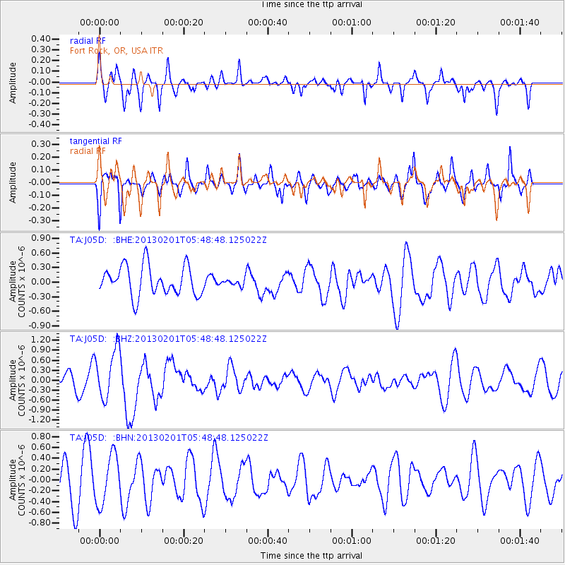
J05D Fort Rock, OR, USA - Earthquake Result Viewer
*The percent match for this event was below the threshold and hence no stack was calculated.
| Earthquake location: |
Santa Cruz Islands |
| Earthquake latitude/longitude: |
-11.1/165.5 |
| Earthquake time(UTC): |
2013/02/01 (032) 05:36:41 GMT |
| Earthquake Depth: |
15 km |
| Earthquake Magnitude: |
5.5 MB, 5.9 MS, 6.0 MW, 6.0 MW |
| Earthquake Catalog/Contributor: |
WHDF/NEIC |
|
| Network: |
TA USArray Transportable Network (new EarthScope stations) |
| Station: |
J05D Fort Rock, OR, USA |
| Lat/Lon: |
43.28 N/121.23 W |
| Elevation: |
1541 m |
|
| Distance: |
85.6 deg |
| Az: |
44.526 deg |
| Baz: |
250.48 deg |
| Ray Param: |
$rayparam |
*The percent match for this event was below the threshold and hence was not used in the summary stack. |
|
| Radial Match: |
58.178486 % |
| Radial Bump: |
400 |
| Transverse Match: |
56.111378 % |
| Transverse Bump: |
400 |
| SOD ConfigId: |
494114 |
| Insert Time: |
2013-04-27 05:34:47.246 +0000 |
| GWidth: |
2.5 |
| Max Bumps: |
400 |
| Tol: |
0.001 |
|
Signal To Noise
| Channel | StoN | STA | LTA |
| TA:J05D: :BHZ:20130201T05:48:48.125022Z | 2.8923028 | 7.543455E-7 | 2.608114E-7 |
| TA:J05D: :BHN:20130201T05:48:48.125022Z | 1.5510517 | 4.655994E-7 | 3.0018302E-7 |
| TA:J05D: :BHE:20130201T05:48:48.125022Z | 0.25353214 | 7.674768E-8 | 3.0271383E-7 |
| Arrivals |
| Ps | |
| PpPs | |
| PsPs/PpSs | |


