You are here: Home > Network List > TA - USArray Transportable Network (new EarthScope stations) Stations List
> Station G03D McMinnville, OR, USA > Earthquake Result Viewer
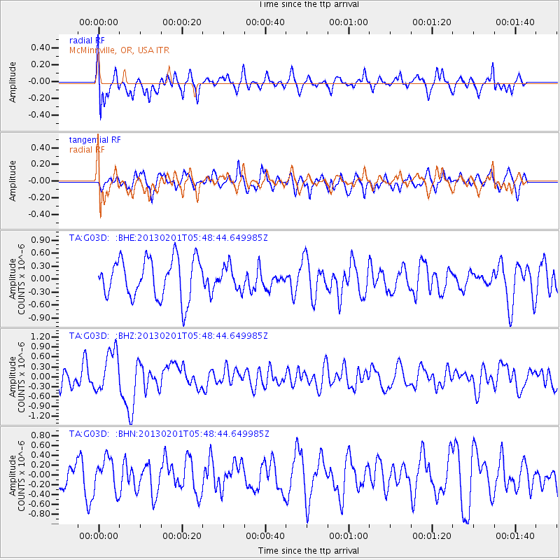
G03D McMinnville, OR, USA - Earthquake Result Viewer
*The percent match for this event was below the threshold and hence no stack was calculated.
| Earthquake location: |
Santa Cruz Islands |
| Earthquake latitude/longitude: |
-11.1/165.5 |
| Earthquake time(UTC): |
2013/02/01 (032) 05:36:41 GMT |
| Earthquake Depth: |
15 km |
| Earthquake Magnitude: |
5.5 MB, 5.9 MS, 6.0 MW, 6.0 MW |
| Earthquake Catalog/Contributor: |
WHDF/NEIC |
|
| Network: |
TA USArray Transportable Network (new EarthScope stations) |
| Station: |
G03D McMinnville, OR, USA |
| Lat/Lon: |
45.21 N/123.26 W |
| Elevation: |
222 m |
|
| Distance: |
84.9 deg |
| Az: |
42.206 deg |
| Baz: |
248.878 deg |
| Ray Param: |
$rayparam |
*The percent match for this event was below the threshold and hence was not used in the summary stack. |
|
| Radial Match: |
46.62041 % |
| Radial Bump: |
400 |
| Transverse Match: |
57.327015 % |
| Transverse Bump: |
400 |
| SOD ConfigId: |
494114 |
| Insert Time: |
2013-04-27 05:34:48.029 +0000 |
| GWidth: |
2.5 |
| Max Bumps: |
400 |
| Tol: |
0.001 |
|
Signal To Noise
| Channel | StoN | STA | LTA |
| TA:G03D: :BHZ:20130201T05:48:44.649985Z | 2.3959143 | 6.384132E-7 | 2.6645912E-7 |
| TA:G03D: :BHN:20130201T05:48:44.649985Z | 1.1678557 | 3.3753122E-7 | 2.8901792E-7 |
| TA:G03D: :BHE:20130201T05:48:44.649985Z | 0.5996839 | 2.7498035E-7 | 4.5854216E-7 |
| Arrivals |
| Ps | |
| PpPs | |
| PsPs/PpSs | |


