You are here: Home > Network List > AU - Australian Seismological Centre Stations List
> Station FORT Forrest, WA > Earthquake Result Viewer
FORT Forrest, WA - Earthquake Result Viewer
| Earthquake location: |
Santa Cruz Islands |
| Earthquake latitude/longitude: |
-10.9/165.4 |
| Earthquake time(UTC): |
2013/02/01 (032) 22:16:34 GMT |
| Earthquake Depth: |
10 km |
| Earthquake Magnitude: |
6.3 MS, 5.3 MB, 6.3 MW, 6.3 MW |
| Earthquake Catalog/Contributor: |
WHDF/NEIC |
|
| Network: |
AU Australian Seismological Centre |
| Station: |
FORT Forrest, WA |
| Lat/Lon: |
30.78 S/128.06 E |
| Elevation: |
165 m |
|
| Distance: |
39.8 deg |
| Az: |
234.543 deg |
| Baz: |
68.372 deg |
| Ray Param: |
0.07475203 |
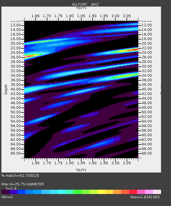
| Estimated Moho Depth: |
25.75 km |
| Estimated Crust Vp/Vs: |
1.60 |
| Assumed Crust Vp: |
6.479 km/s |
| Estimated Crust Vs: |
4.05 km/s |
| Estimated Crust Poisson's Ratio: |
0.18 |
|
| Radial Match: |
92.705025 % |
| Radial Bump: |
400 |
| Transverse Match: |
62.453865 % |
| Transverse Bump: |
400 |
| SOD ConfigId: |
494114 |
| Insert Time: |
2013-04-27 05:39:11.382 +0000 |
| GWidth: |
2.5 |
| Max Bumps: |
400 |
| Tol: |
0.001 |
|

Signal To Noise
| Channel | StoN | STA | LTA |
| AU:FORT: :BHZ:20130201T22:23:36.770006Z | 2.5987198 | 9.96633E-7 | 3.8350922E-7 |
| AU:FORT: :BHN:20130201T22:23:36.770006Z | 1.0777253 | 4.0495195E-7 | 3.757469E-7 |
| AU:FORT: :BHE:20130201T22:23:36.770006Z | 2.5465991 | 7.6404774E-7 | 3.000267E-7 |
| Arrivals |
| Ps | 2.6 SECOND |
| PpPs | 9.5 SECOND |
| PsPs/PpSs | 12 SECOND |


