You are here: Home > Network List > GT - Global Telemetered Seismograph Network (USAF/USGS) Stations List
> Station BDFB Brasilia, Brazil > Earthquake Result Viewer
BDFB Brasilia, Brazil - Earthquake Result Viewer
| Earthquake location: |
Pacific-Antarctic Ridge |
| Earthquake latitude/longitude: |
-54.4/-137.0 |
| Earthquake time(UTC): |
2001/09/02 (245) 10:06:51 GMT |
| Earthquake Depth: |
10 km |
| Earthquake Magnitude: |
5.6 MB, 6.3 MS, 6.3 MW, 6.3 MW |
| Earthquake Catalog/Contributor: |
WHDF/NEIC |
|
| Network: |
GT Global Telemetered Seismograph Network (USAF/USGS) |
| Station: |
BDFB Brasilia, Brazil |
| Lat/Lon: |
15.64 S/48.01 W |
| Elevation: |
1195 m |
|
| Distance: |
76.9 deg |
| Az: |
98.457 deg |
| Baz: |
216.937 deg |
| Ray Param: |
0.050700817 |
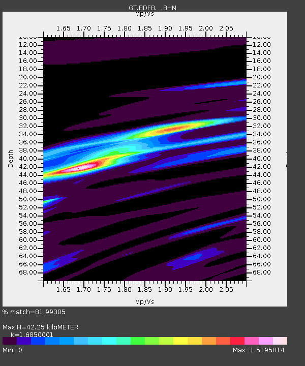
| Estimated Moho Depth: |
42.25 km |
| Estimated Crust Vp/Vs: |
1.69 |
| Assumed Crust Vp: |
6.419 km/s |
| Estimated Crust Vs: |
3.81 km/s |
| Estimated Crust Poisson's Ratio: |
0.23 |
|
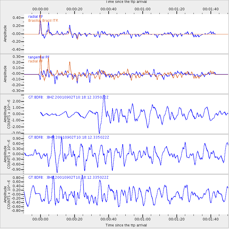
| Radial Match: |
81.99305 % |
| Radial Bump: |
400 |
| Transverse Match: |
56.958992 % |
| Transverse Bump: |
400 |
| SOD ConfigId: |
20082 |
| Insert Time: |
2010-02-27 01:36:37.489 +0000 |
| GWidth: |
2.5 |
| Max Bumps: |
400 |
| Tol: |
0.001 |
|
Signal To Noise
| Channel | StoN | STA | LTA |
| GT:BDFB: :BHN:20010902T10:18:12.335022Z | 1.9614813 | 2.064801E-7 | 1.05267425E-7 |
| GT:BDFB: :BHE:20010902T10:18:12.335022Z | 0.88214195 | 2.4902255E-7 | 2.8229306E-7 |
| GT:BDFB: :BHZ:20010902T10:18:12.335022Z | 4.547001 | 1.0168853E-6 | 2.2363868E-7 |
| Arrivals |
| Ps | 4.7 SECOND |
| PpPs | 17 SECOND |
| PsPs/PpSs | 22 SECOND |


