You are here: Home > Network List > AZ - ANZA Regional Network Stations List
> Station SMER AZ.SMER > Earthquake Result Viewer
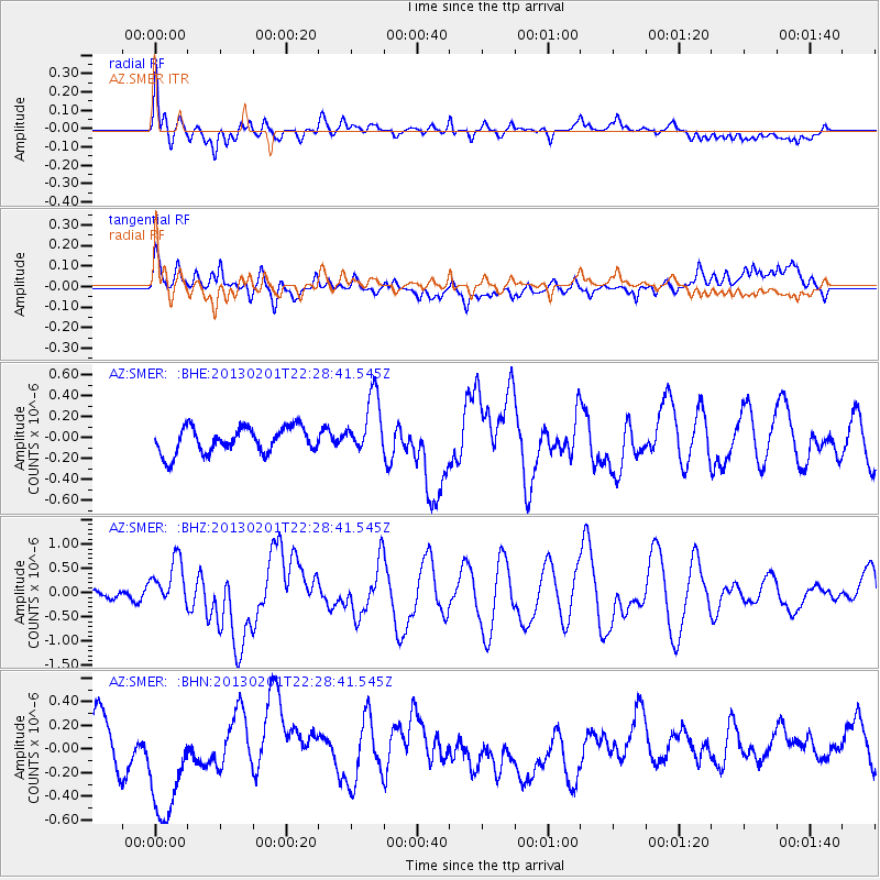
SMER AZ.SMER - Earthquake Result Viewer
*The percent match for this event was below the threshold and hence no stack was calculated.
| Earthquake location: |
Santa Cruz Islands |
| Earthquake latitude/longitude: |
-10.9/165.4 |
| Earthquake time(UTC): |
2013/02/01 (032) 22:16:34 GMT |
| Earthquake Depth: |
10 km |
| Earthquake Magnitude: |
6.3 MS, 5.3 MB, 6.3 MW, 6.3 MW |
| Earthquake Catalog/Contributor: |
WHDF/NEIC |
|
| Network: |
AZ ANZA Regional Network |
| Station: |
SMER AZ.SMER |
| Lat/Lon: |
33.46 N/117.17 W |
| Elevation: |
355 m |
|
| Distance: |
85.7 deg |
| Az: |
54.919 deg |
| Baz: |
254.044 deg |
| Ray Param: |
$rayparam |
*The percent match for this event was below the threshold and hence was not used in the summary stack. |
|
| Radial Match: |
74.09334 % |
| Radial Bump: |
400 |
| Transverse Match: |
39.653645 % |
| Transverse Bump: |
400 |
| SOD ConfigId: |
494114 |
| Insert Time: |
2013-04-27 05:41:10.192 +0000 |
| GWidth: |
2.5 |
| Max Bumps: |
400 |
| Tol: |
0.001 |
|
Signal To Noise
| Channel | StoN | STA | LTA |
| AZ:SMER: :BHZ:20130201T22:28:41.545Z | 5.4755936 | 4.8662E-7 | 8.8870735E-8 |
| AZ:SMER: :BHN:20130201T22:28:41.545Z | 1.5066984 | 5.083038E-7 | 3.3736268E-7 |
| AZ:SMER: :BHE:20130201T22:28:41.545Z | 2.3007832 | 2.8235178E-7 | 1.2271985E-7 |
| Arrivals |
| Ps | |
| PpPs | |
| PsPs/PpSs | |


