You are here: Home > Network List > GT - Global Telemetered Seismograph Network (USAF/USGS) Stations List
> Station BDFB Brasilia, Brazil > Earthquake Result Viewer
BDFB Brasilia, Brazil - Earthquake Result Viewer

| Earthquake location: |
Mexico-Guatemala Border Region |
| Earthquake latitude/longitude: |
15.4/-92.7 |
| Earthquake time(UTC): |
2001/01/19 (019) 01:12:52 GMT |
| Earthquake Depth: |
93 km |
| Earthquake Magnitude: |
5.4 MB, 5.6 MD |
| Earthquake Catalog/Contributor: |
WHDF/NEIC |
|
| Network: |
GT Global Telemetered Seismograph Network (USAF/USGS) |
| Station: |
BDFB Brasilia, Brazil |
| Lat/Lon: |
15.64 S/48.01 W |
| Elevation: |
1195 m |
|
| Distance: |
53.9 deg |
| Az: |
122.945 deg |
| Baz: |
302.843 deg |
| Ray Param: |
0.06553821 |
| Estimated Moho Depth: |
42.75 km |
| Estimated Crust Vp/Vs: |
1.66 |
| Assumed Crust Vp: |
6.419 km/s |
| Estimated Crust Vs: |
3.867 km/s |
| Estimated Crust Poisson's Ratio: |
0.22 |
|
| Radial Match: |
83.81694 % |
| Radial Bump: |
400 |
| Transverse Match: |
71.60006 % |
| Transverse Bump: |
400 |
| SOD ConfigId: |
3753 |
| Insert Time: |
2010-02-27 01:36:42.664 +0000 |
| GWidth: |
2.5 |
| Max Bumps: |
400 |
| Tol: |
0.001 |
|
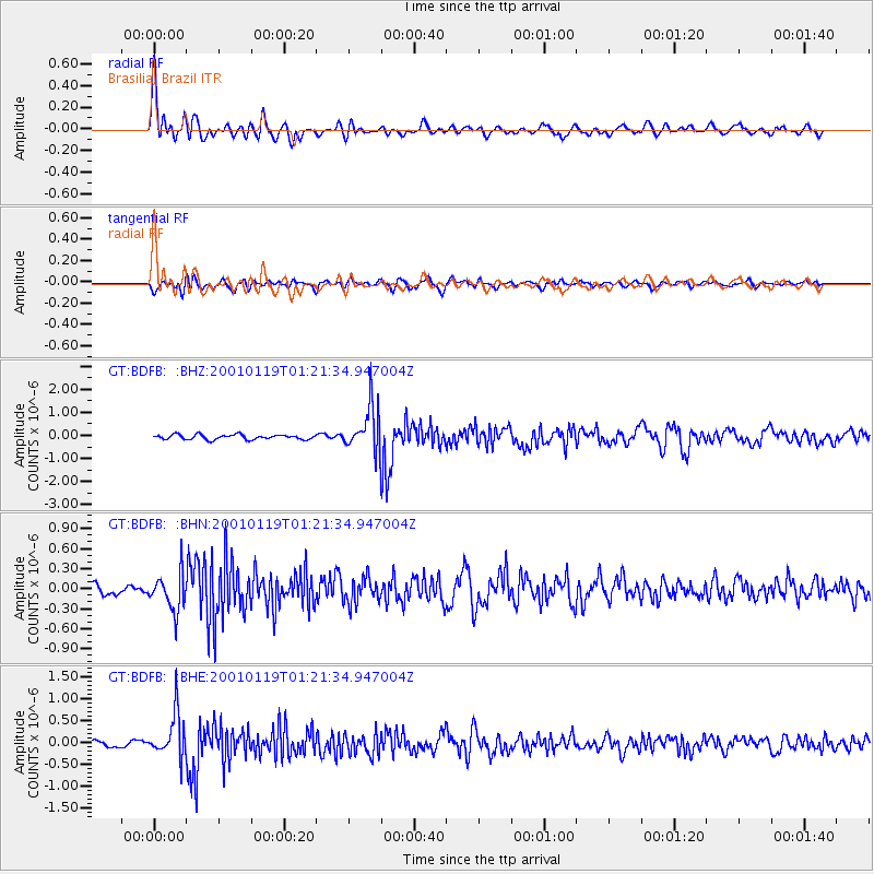
Signal To Noise
| Channel | StoN | STA | LTA |
| GT:BDFB: :BHN:20010119T01:21:34.947004Z | 3.9774003 | 2.7588914E-7 | 6.936419E-8 |
| GT:BDFB: :BHE:20010119T01:21:34.947004Z | 5.9961405 | 5.0259763E-7 | 8.382019E-8 |
| GT:BDFB: :BHZ:20010119T01:21:34.947004Z | 9.157105 | 9.639334E-7 | 1.05266174E-7 |
| Arrivals |
| Ps | 4.7 SECOND |
| PpPs | 17 SECOND |
| PsPs/PpSs | 21 SECOND |


