BDFB Brasilia, Brazil - Earthquake Result Viewer
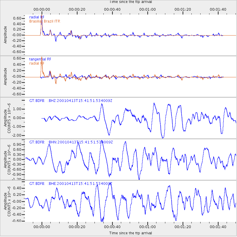
Earthquake location: South Sandwich Islands Region
Earthquake latitude/longitude: -59.7/-25.6
Earthquake time(UTC): 2001/04/13 (103) 15:33:53 GMT
Earthquake Depth: 26 km
Earthquake Magnitude: 5.3 MB, 6.0 MS, 6.2 MW, 6.2 MW
Earthquake Catalog/Contributor: WHDF/NEIC
Network: GT Global Telemetered Seismograph Network (USAF/USGS)
Station: BDFB Brasilia, Brazil
Lat/Lon: 15.64 S/48.01 W
Elevation: 1195 m
Distance: 47.0 deg
Az: 329.817 deg
Baz: 164.667 deg
Ray Param: 0.07024943
Estimated Moho Depth: 43.25 km
Estimated Crust Vp/Vs: 1.66
Assumed Crust Vp: 6.419 km/s
Estimated Crust Vs: 3.873 km/s
Estimated Crust Poisson's Ratio: 0.21
Radial Match: 92.6006 %
Radial Bump: 280
Transverse Match: 70.325294 %
Transverse Bump: 400
SOD ConfigId: 4714
Insert Time: 2010-02-27 01:36:48.021 +0000
GWidth: 2.5
Max Bumps: 400
Tol: 0.001

Signal To Noise

ChannelStoNSTALTA
GT:BDFB: :BHN:20010413T15:41:51.534009Z4.1049464.841484E-71.179427E-7
GT:BDFB: :BHE:20010413T15:41:51.534009Z1.19346951.4619977E-71.2249978E-7
GT:BDFB: :BHZ:20010413T15:41:51.534009Z4.65872577.58774E-71.6287159E-7
Arrivals
Ps4.7 SECOND
PpPs17 SECOND
PsPs/PpSs21 SECOND