You are here: Home > Network List > LB - Leo Brady Network Stations List
> Station DAC Darwin, Inyo County, California, USA > Earthquake Result Viewer
DAC Darwin, Inyo County, California, USA - Earthquake Result Viewer
| Earthquake location: |
Santa Cruz Islands |
| Earthquake latitude/longitude: |
-10.9/165.4 |
| Earthquake time(UTC): |
2013/02/01 (032) 22:16:34 GMT |
| Earthquake Depth: |
10 km |
| Earthquake Magnitude: |
6.3 MS, 5.3 MB, 6.3 MW, 6.3 MW |
| Earthquake Catalog/Contributor: |
WHDF/NEIC |
|
| Network: |
LB Leo Brady Network |
| Station: |
DAC Darwin, Inyo County, California, USA |
| Lat/Lon: |
36.28 N/117.59 W |
| Elevation: |
1813 m |
|
| Distance: |
86.1 deg |
| Az: |
52.114 deg |
| Baz: |
253.603 deg |
| Ray Param: |
0.04427214 |
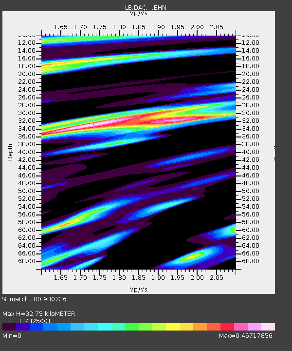
| Estimated Moho Depth: |
32.75 km |
| Estimated Crust Vp/Vs: |
1.73 |
| Assumed Crust Vp: |
6.279 km/s |
| Estimated Crust Vs: |
3.624 km/s |
| Estimated Crust Poisson's Ratio: |
0.25 |
|
| Radial Match: |
80.980736 % |
| Radial Bump: |
317 |
| Transverse Match: |
62.674007 % |
| Transverse Bump: |
400 |
| SOD ConfigId: |
494114 |
| Insert Time: |
2013-04-27 05:46:34.373 +0000 |
| GWidth: |
2.5 |
| Max Bumps: |
400 |
| Tol: |
0.001 |
|

Signal To Noise
| Channel | StoN | STA | LTA |
| LB:DAC: :BHZ:20130201T22:28:43.758989Z | 3.6199725 | 4.5867452E-7 | 1.2670664E-7 |
| LB:DAC: :BHN:20130201T22:28:43.758989Z | 1.023853 | 1.279862E-7 | 1.2500448E-7 |
| LB:DAC: :BHE:20130201T22:28:43.758989Z | 1.1399422 | 1.5845357E-7 | 1.3900141E-7 |
| Arrivals |
| Ps | 3.9 SECOND |
| PpPs | 14 SECOND |
| PsPs/PpSs | 18 SECOND |


