You are here: Home > Network List > TA - USArray Transportable Network (new EarthScope stations) Stations List
> Station TPFO Pinon Flats, CA, USA > Earthquake Result Viewer
TPFO Pinon Flats, CA, USA - Earthquake Result Viewer
| Earthquake location: |
Santa Cruz Islands |
| Earthquake latitude/longitude: |
-10.9/165.4 |
| Earthquake time(UTC): |
2013/02/01 (032) 22:16:34 GMT |
| Earthquake Depth: |
10 km |
| Earthquake Magnitude: |
6.3 MS, 5.3 MB, 6.3 MW, 6.3 MW |
| Earthquake Catalog/Contributor: |
WHDF/NEIC |
|
| Network: |
TA USArray Transportable Network (new EarthScope stations) |
| Station: |
TPFO Pinon Flats, CA, USA |
| Lat/Lon: |
33.61 N/116.45 W |
| Elevation: |
1275 m |
|
| Distance: |
86.3 deg |
| Az: |
54.94 deg |
| Baz: |
254.439 deg |
| Ray Param: |
0.044154108 |
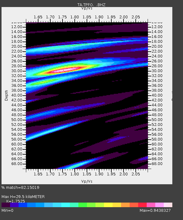
| Estimated Moho Depth: |
29.5 km |
| Estimated Crust Vp/Vs: |
1.75 |
| Assumed Crust Vp: |
6.264 km/s |
| Estimated Crust Vs: |
3.574 km/s |
| Estimated Crust Poisson's Ratio: |
0.26 |
|
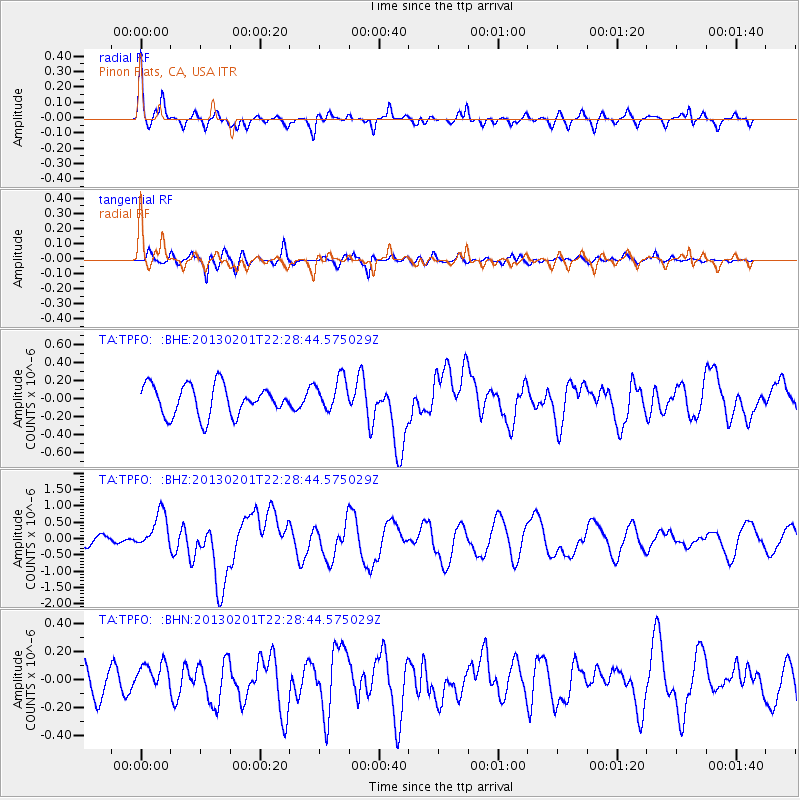
| Radial Match: |
82.15019 % |
| Radial Bump: |
367 |
| Transverse Match: |
59.801846 % |
| Transverse Bump: |
400 |
| SOD ConfigId: |
494114 |
| Insert Time: |
2013-04-27 05:48:42.012 +0000 |
| GWidth: |
2.5 |
| Max Bumps: |
400 |
| Tol: |
0.001 |
|
Signal To Noise
| Channel | StoN | STA | LTA |
| TA:TPFO: :BHZ:20130201T22:28:44.575029Z | 2.9645948 | 5.5438284E-7 | 1.8700122E-7 |
| TA:TPFO: :BHN:20130201T22:28:44.575029Z | 0.79625374 | 9.670781E-8 | 1.2145351E-7 |
| TA:TPFO: :BHE:20130201T22:28:44.575029Z | 1.1022187 | 1.8321337E-7 | 1.6622234E-7 |
| Arrivals |
| Ps | 3.6 SECOND |
| PpPs | 13 SECOND |
| PsPs/PpSs | 16 SECOND |


