You are here: Home > Network List > UW - Pacific Northwest Regional Seismic Network Stations List
> Station MRBL Marblemount, WA, USA > Earthquake Result Viewer
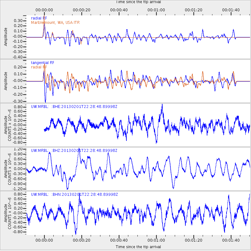
MRBL Marblemount, WA, USA - Earthquake Result Viewer
*The percent match for this event was below the threshold and hence no stack was calculated.
| Earthquake location: |
Santa Cruz Islands |
| Earthquake latitude/longitude: |
-10.9/165.4 |
| Earthquake time(UTC): |
2013/02/01 (032) 22:16:34 GMT |
| Earthquake Depth: |
10 km |
| Earthquake Magnitude: |
6.3 MS, 5.3 MB, 6.3 MW, 6.3 MW |
| Earthquake Catalog/Contributor: |
WHDF/NEIC |
|
| Network: |
UW Pacific Northwest Regional Seismic Network |
| Station: |
MRBL Marblemount, WA, USA |
| Lat/Lon: |
48.52 N/121.48 W |
| Elevation: |
75 m |
|
| Distance: |
87.2 deg |
| Az: |
39.573 deg |
| Baz: |
250.238 deg |
| Ray Param: |
$rayparam |
*The percent match for this event was below the threshold and hence was not used in the summary stack. |
|
| Radial Match: |
56.88602 % |
| Radial Bump: |
400 |
| Transverse Match: |
44.76558 % |
| Transverse Bump: |
400 |
| SOD ConfigId: |
494114 |
| Insert Time: |
2013-04-27 05:50:10.022 +0000 |
| GWidth: |
2.5 |
| Max Bumps: |
400 |
| Tol: |
0.001 |
|
Signal To Noise
| Channel | StoN | STA | LTA |
| UW:MRBL: :BHZ:20130201T22:28:48.89998Z | 2.6518202 | 4.939977E-7 | 1.8628626E-7 |
| UW:MRBL: :BHN:20130201T22:28:48.89998Z | 0.6955025 | 1.7800002E-7 | 2.559301E-7 |
| UW:MRBL: :BHE:20130201T22:28:48.89998Z | 0.9428093 | 1.7221522E-7 | 1.8266178E-7 |
| Arrivals |
| Ps | |
| PpPs | |
| PsPs/PpSs | |


