You are here: Home > Network List > GT - Global Telemetered Seismograph Network (USAF/USGS) Stations List
> Station BDFB Brasilia, Brazil > Earthquake Result Viewer
BDFB Brasilia, Brazil - Earthquake Result Viewer
| Earthquake location: |
South Sandwich Islands Region |
| Earthquake latitude/longitude: |
-56.5/-27.5 |
| Earthquake time(UTC): |
2002/11/12 (316) 01:46:48 GMT |
| Earthquake Depth: |
120 km |
| Earthquake Magnitude: |
6.0 MB, 6.3 MW, 6.2 MW |
| Earthquake Catalog/Contributor: |
WHDF/NEIC |
|
| Network: |
GT Global Telemetered Seismograph Network (USAF/USGS) |
| Station: |
BDFB Brasilia, Brazil |
| Lat/Lon: |
15.64 S/48.01 W |
| Elevation: |
1195 m |
|
| Distance: |
43.7 deg |
| Az: |
330.801 deg |
| Baz: |
163.715 deg |
| Ray Param: |
0.071954325 |
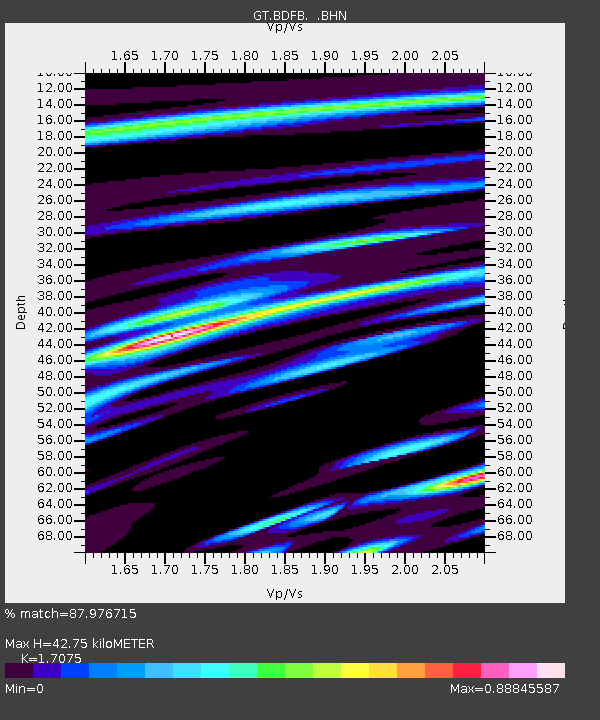
| Estimated Moho Depth: |
42.75 km |
| Estimated Crust Vp/Vs: |
1.71 |
| Assumed Crust Vp: |
6.419 km/s |
| Estimated Crust Vs: |
3.759 km/s |
| Estimated Crust Poisson's Ratio: |
0.24 |
|
| Radial Match: |
87.976715 % |
| Radial Bump: |
400 |
| Transverse Match: |
74.03186 % |
| Transverse Bump: |
400 |
| SOD ConfigId: |
4714 |
| Insert Time: |
2010-02-27 01:36:52.435 +0000 |
| GWidth: |
2.5 |
| Max Bumps: |
400 |
| Tol: |
0.001 |
|
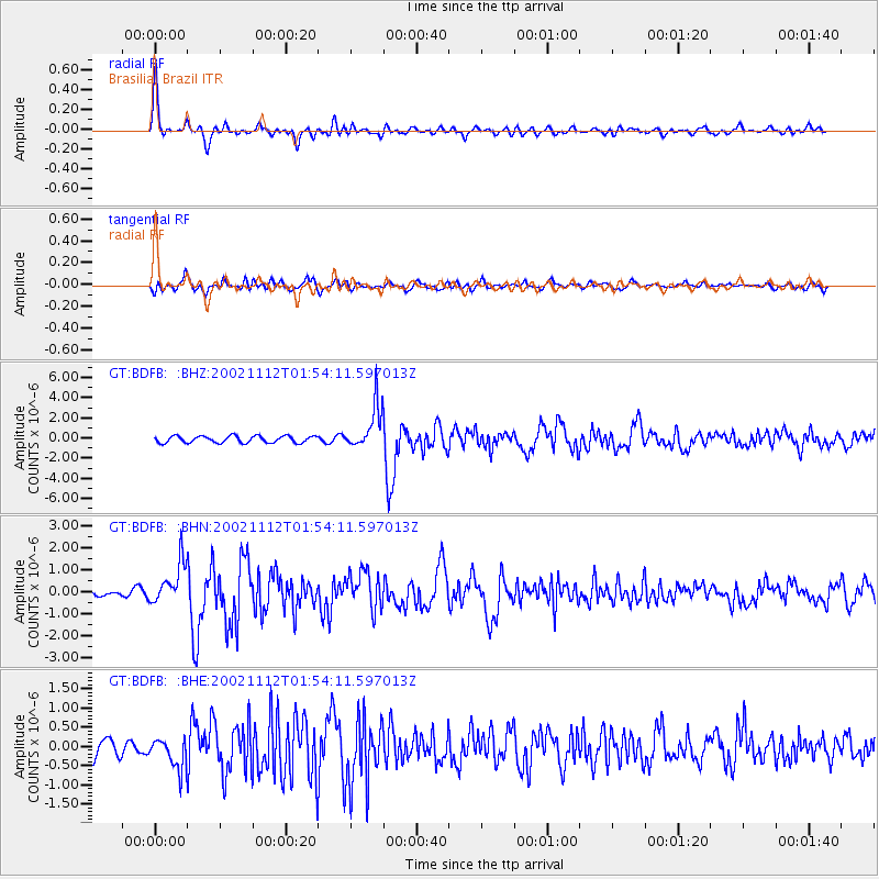
Signal To Noise
| Channel | StoN | STA | LTA |
| GT:BDFB: :BHN:20021112T01:54:11.597013Z | 5.246558 | 9.4221133E-7 | 1.7958655E-7 |
| GT:BDFB: :BHE:20021112T01:54:11.597013Z | 1.5923283 | 4.0056034E-7 | 2.5155637E-7 |
| GT:BDFB: :BHZ:20021112T01:54:11.597013Z | 6.3808 | 2.153236E-6 | 3.374555E-7 |
| Arrivals |
| Ps | 5.0 SECOND |
| PpPs | 17 SECOND |
| PsPs/PpSs | 22 SECOND |


