You are here: Home > Network List > GT - Global Telemetered Seismograph Network (USAF/USGS) Stations List
> Station BDFB Brasilia, Brazil > Earthquake Result Viewer
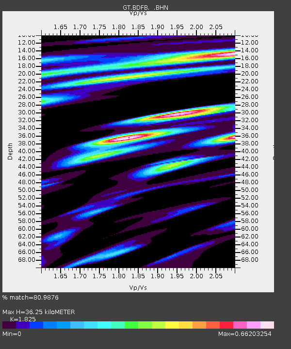
BDFB Brasilia, Brazil - Earthquake Result Viewer
| Earthquake location: |
Guerrero, Mexico |
| Earthquake latitude/longitude: |
18.3/-101.5 |
| Earthquake time(UTC): |
1999/06/21 (172) 17:43:04 GMT |
| Earthquake Depth: |
69 km |
| Earthquake Magnitude: |
6.0 MB, 5.8 MS, 6.3 MW, 5.8 MD |
| Earthquake Catalog/Contributor: |
WHDF/NEIC |
|
| Network: |
GT Global Telemetered Seismograph Network (USAF/USGS) |
| Station: |
BDFB Brasilia, Brazil |
| Lat/Lon: |
15.64 S/48.01 W |
| Elevation: |
1195 m |
|
| Distance: |
62.6 deg |
| Az: |
119.23 deg |
| Baz: |
300.636 deg |
| Ray Param: |
0.05995602 |
| Estimated Moho Depth: |
36.25 km |
| Estimated Crust Vp/Vs: |
1.83 |
| Assumed Crust Vp: |
6.419 km/s |
| Estimated Crust Vs: |
3.517 km/s |
| Estimated Crust Poisson's Ratio: |
0.29 |
|
| Radial Match: |
80.9876 % |
| Radial Bump: |
400 |
| Transverse Match: |
75.969185 % |
| Transverse Bump: |
400 |
| SOD ConfigId: |
4480 |
| Insert Time: |
2010-02-27 01:36:53.711 +0000 |
| GWidth: |
2.5 |
| Max Bumps: |
400 |
| Tol: |
0.001 |
|

Signal To Noise
| Channel | StoN | STA | LTA |
| GT:BDFB: :BHN:19990621T17:52:50.746013Z | 3.1451888 | 6.296942E-7 | 2.0020872E-7 |
| GT:BDFB: :BHE:19990621T17:52:50.746013Z | 1.8816237 | 2.9762987E-7 | 1.5817713E-7 |
| GT:BDFB: :BHZ:19990621T17:52:50.746013Z | 4.5741796 | 4.4078647E-7 | 9.636405E-8 |
| Arrivals |
| Ps | 4.9 SECOND |
| PpPs | 15 SECOND |
| PsPs/PpSs | 20 SECOND |


