You are here: Home > Network List > GT - Global Telemetered Seismograph Network (USAF/USGS) Stations List
> Station BDFB Brasilia, Brazil > Earthquake Result Viewer
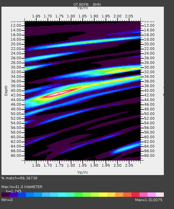
BDFB Brasilia, Brazil - Earthquake Result Viewer
| Earthquake location: |
Colombia |
| Earthquake latitude/longitude: |
3.9/-75.8 |
| Earthquake time(UTC): |
1997/12/11 (345) 07:56:28 GMT |
| Earthquake Depth: |
178 km |
| Earthquake Magnitude: |
6.0 MB, 6.4 UNKNOWN, 6.3 MW |
| Earthquake Catalog/Contributor: |
WHDF/NEIC |
|
| Network: |
GT Global Telemetered Seismograph Network (USAF/USGS) |
| Station: |
BDFB Brasilia, Brazil |
| Lat/Lon: |
15.64 S/48.01 W |
| Elevation: |
1195 m |
|
| Distance: |
33.7 deg |
| Az: |
125.932 deg |
| Baz: |
303.018 deg |
| Ray Param: |
0.07751477 |
| Estimated Moho Depth: |
41.0 km |
| Estimated Crust Vp/Vs: |
1.75 |
| Assumed Crust Vp: |
6.419 km/s |
| Estimated Crust Vs: |
3.679 km/s |
| Estimated Crust Poisson's Ratio: |
0.26 |
|
| Radial Match: |
96.36738 % |
| Radial Bump: |
294 |
| Transverse Match: |
92.34285 % |
| Transverse Bump: |
400 |
| SOD ConfigId: |
4480 |
| Insert Time: |
2010-02-27 01:36:56.593 +0000 |
| GWidth: |
2.5 |
| Max Bumps: |
400 |
| Tol: |
0.001 |
|

Signal To Noise
| Channel | StoN | STA | LTA |
| GT:BDFB: :BHN:19971211T08:02:22.388989Z | 73.778076 | 6.9161724E-6 | 9.374292E-8 |
| GT:BDFB: :BHE:19971211T08:02:22.388989Z | 32.84124 | 2.4908786E-6 | 7.584605E-8 |
| GT:BDFB: :BHZ:19971211T08:02:22.388989Z | 59.03647 | 4.9558234E-6 | 8.3945125E-8 |
| Arrivals |
| Ps | 5.1 SECOND |
| PpPs | 16 SECOND |
| PsPs/PpSs | 21 SECOND |


